Shanghai Local Snacks


Shanghai Local Snacks

Walk down one of Shanghai’s celebrated snack streets and you’ll be met with a dizzying array of aromas, each one more tempting than the last. From sizzling skewers of tender beef to steaming containers rich with plump dumplings, you’ll be sure to find a treat to suit anyone’s palate. Shanghai cuisine is characterised by its emphasis on three elements: colour, aroma, and taste. Popular ingredients include fresh fish, shellfish, chicken, pork, soy sauce, sugar, and various vegetables. Over time, this has resulted in a myriad of snacks that are light, fresh, and bursting with the natural flavour of their ingredients!

Xiaolongbao (小笼包)

SHANGHAI Xiaolongbao
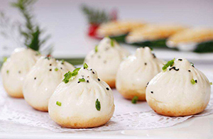
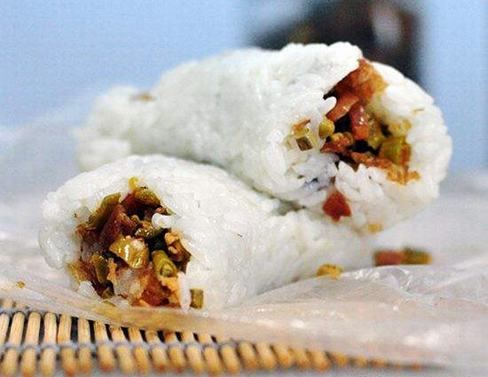
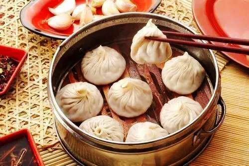
Of all the local delicacies in Shanghai, this is undoubtedly the most well-known. With over one hundred years of history behind it, local vendors have had plenty of time to perfect this sumptuous snack! Xiaolongbao, also known as Shanghai dumplings, are a type of steamed bun made with a thin skin of dough. They are commonly stuffed with pork, although some variations use minced crab meat and crab roe. Xiaolongbao are wrapped and sealed differently to other types of dumpling, and this is because of their one unique ingredient. Each tiny parcel is filled to the brim with a delicious broth!

This is usually made by mixing Shaoxing rice wine with pork jelly, which melts as the dumplings are cooked. That being said, each vendor has their own secret recipe for their signature soup! Although the wrappers may seem delicate, a well-made xiaolongbao will hold in the soup even when it is lifted up with a pair of chopsticks. A batch of these tasty treats are typically steamed in a bamboo basket before being served with a sauce made from black vinegar and, in some places, shredded ginger.

Remember, these aren’t just your average dumplings, and you’ll want to eat them in the correct way to avoid a scalded tongue! The best way to eat xiaolongbao is to place it on a spoon, bite off the top, drink the soup, then dip the remaining dumpling in the vinegar sauce before eating it. The most well-known type of xiaolongbao, known as Nanxiang Xiaolongbao, is usually stuffed with pork, pork jelly, ground sesame seeds, shredded bamboo, and shrimp. It comes from Nanxiang Township in Shanghai’s suburbs, although it can be found throughout the city.

Shengjianbao (生煎包)

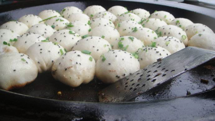
Shengjianbao or Pan-Fried Pork Buns are Xiaolongbao’s chubby cousins. They’re bigger, bolder, and bursting with flavour! Like Xiaolongbao, Shengjianbao have been a popular local snack in the region for over a hundred years. They are made by wrapping fresh pork and pork jelly in a dough made from half-risen flour. This dough is made using yeast, meaning it’s a little thicker than your average dumpling skin, and the topknot is tucked underneath rather than sitting on top.

The buns are pan-fried, with cold water being periodically added to the pan. A lid is used to cover the buns and keep in the steam. This results in the bottoms of the dumplings being fried, while the tops are steamed. Right before they are fully cooked, a smattering of chopped spring onions and sesame seeds are sprinkled on top of the buns. The perfect Shengjianbao has a thin skin, a fragrant filling, and a crispy golden base. Many restaurants throughout Shanghai serve variations on this simple treat, including ones filled with chicken and crab meat.

Cifantuan (糍饭团)

CifantuanKnown as one of the “Four Heavenly Kings”, Cifantuan is one of the four most popular breakfast foods in China. It originates from Shanghai and is made by wrapping a piece of fried dough, known as youtiao, in glutinous rice. It comes in two varieties: sweet and savoury. Sweet Cifantuan is made by simply adding sugar and sometimes sesame paste to the filling, while the savoury version includes ingredients such as pickled vegetables, salted duck eggs, and shredded pork floss. They are particularly popular in Taiwan, Hong Kong, and eastern China, where they’re eaten with sweet or savoury soy milk as part of a balanced breakfast. Modern variations on the traditional Cifantuan have been adapted in Taiwan and Hong Kong before being re-introduced to Shanghai.

Crab Shell Cake (蟹壳)

Crab Shell Cake
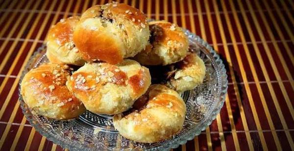
Don’t let the name fool you, Crab Shell Cake is named for its colour, not its content! The name derives from the snack’s distinctively yellowy brown hue, which is said to resemble that of a cooked crab shell. The outer casing is a type of shortbread made from flour, oil, and sesame seeds, which is stuffed with sweet or savoury fillings. While some variations of Crab Shell Cake do contain crab meat, other popular ingredients include pork, shrimp, sugar, rose petal paste, sweet red bean paste, and jujube paste. The cake’s delightfully crispy exterior is complemented perfectly by the smooth texture of its filling.

Yangchun Noodles (阳春面)

yangchun noodles
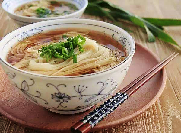
According to the Chinese lunar calendar, the tenth month is referred to as “Little Yangchun”, and it is a local Shanghai-ese custom to use “yangchun” as an alternative term for the number “ten”. When these noodles first became popular in the area, they only cost a meagre 10 fen[1], so the local people naturally began called them Yangchun Noodles. Like an embarrassing nickname, this title seems to have stuck! These noodles are served simply in a clear soup, usually with a dash of scented scallion oil to give them an added kick.

[1] Fen: A unit of currency that is used throughout China. One fen is equal to one-hundredth of a yuan or one-tenth of a Chinese jiao.

Taste some Shanghai Local Snacks on our travel Explore Chinese Culture through the Ages

Jiaohe Ruins

jiaohe relics02

Nestled within the Yarnaz Valley just 10 kilometres (6 mi) west of Turpan, the Jiaohe Ruins will transport you back to the heart of the Silk Road. The history of this ancient city stretches back over some 2,300 years, making it one of the oldest earthen cities still in existence, and it was unsurprisingly incorporated into the Silk Road UNESCO World Heritage Site in 2014. After all, at the grand old age of 2,300, you’d expect to finally be able to retire!

It was once the capital of the Jushi or Cheshi Kingdom, which ruled the area throughout most of the Han Dynasty (206 BC–220 AD), but the city was captured by the Han court during the 1st century BC. It soon became a focal trade hub along the Silk Road and, as an oasis town, it was considered invaluable. The entire region, including Jiaohe, was annexed by the Gaochang Kingdom (531-640) during the 6th century but returned to Chinese control in 640, during the Tang Dynasty (618-907), when it was conquered by Emperor Taizong. It was during this period that the city flourished as a centre of trade between China and Central Asia.

day16 07At the beginning of the 9th century, the area came under the control of the Uyghur people and was part of a kingdom known as the Uyghur Khaganate (744–840), until their territory was eventually conquered by the Kyrgyz people in 840. Though the city continued to thrive under Uyghur and Kyrgyz rule, it was destroyed during warfare towards the end of the 13th century when the Mongolian warlord Kaidu rebelled against his cousin Kublai Khan, the grandson of Genghis Khan and the founder of the Yuan Dynasty (1271-1368). It remained a ghost town for many hundreds of years, until it was finally rediscovered and partially excavated during the 1950s. Since then, Jiaohe has gone from deserted spectre to adored superstar!

The city was built on a large islet nestled between two deep river valleys and was thus named Jiaohe, which translates to mean “where two rivers meet”. Yarkhoto, the alternative name for the city, may be derived from the Turkic word “yar”, meaning “ravine”, and the Mongolian word “khoto”, meaning “town”. The steep cliffs on all sides tower in at over 30 metres (98 ft.) in height and once served as a natural protective barrier, so city walls were never constructed. There were originally only two gates leading into the city, but the South Gate has since vanished and only fragments of the East Gate remain.

jiaohe relicsThe city is separated into three districts: eastern, western, and northern. The eastern and western districts were residential, with the east largely inhabited by aristocrats and the west belonging mainly to commoners. The northern district was reserved entirely for religious sites, such as Buddhist temples and stupas[1]. Towards the centre of the city, there are a number of governmental buildings that have been exceptionally well-preserved.

According to Tang imperial records, in its heyday the city was home to 6,500 residents, 700 households, and 865 soldiers, and many of its surviving buildings date back to the Tang Dynasty. The doors and windows of the buildings do not face the street, which is a peculiarity of Tang-style architecture, and several of the courtyards have been physically dug out from the earth like a pit, which is a rare phenomenon found mainly in northwest China. All of the buildings are made from packed-earth and they have managed to remain in such good condition thanks to the extremely dry climate in the region.

jiaohe ruins02A stroll down Jiaohe’s central avenue rewards visitors with the greatest views, as it cuts through the city and provides access to all three districts. At the end, there is a stunning Buddhist temple known as Jiaohe Temple or the Great Monastery and, in the northernmost part of the city, there are a group of 101 stupas that date back to between the 5th and 7th centuries, known as Stupa Grove.

Many of the relics that were excavated from the city are now housed in either the Turpan Museum in Turpan or the Xinjiang Museum in Ürümqi. However, near the ruins there is a museum dedicated to the Cheshi (Jushi) people, who were Jiaohe’s original inhabitants. Bizarrely these people were of Caucasian descent and had light hair and blue eyes, unlike the Han and Uyghur ethnic groups that populate the area now. They have enjoyed some fame recently as evidence suggests they were probably the first cultivators of cannabis (marijuana). We’re sure this discovery must have given the researchers a real high!


[1] Stupa: A hemispherical structure with a small interior designed for storing Buddhist relics and for private meditation.


Join a travel with us to explore more about Jiaohe RuinsExplore the Silk Road in China

Ejin Banner

Ejin 01

Where hooves once thundered across the verdant grasslands, the feet of intrepid explorers now tread. Historically, Ejin Banner served as the hunting grounds of the fearsome Xiongnu people until the region was conquered by the Han Dynasty (206 BC–220 AD) in 121 BC. In 1226, it was incorporated into the Mongol Empire (1206-1368) by Genghis Khan and, during the Mongol-led Yuan Dynasty (1271-1368), it became home to a vast constituency of Mongolian nomads. The term “banner” is Mongolian and refers to an administrative division much like a county. Resting within the hostile Gobi Desert, Ejin is the westernmost banner in Inner Mongolia. It borders Gansu province to the southwest and Mongolia to the north. Although the majority of the population is now Han Chinese, it is still regarded as a culturally Mongolian region.

Not only is it larger than the provinces of Jiangsu and Zhejiang, it is so geographically vast that it is roughly the size of South Korea! Its name is derived from the Ejin River, which flows from the Qilian Mountains in Gansu province through to the Juyan Lake Basin within the region. Ejin Banner is famed for its diverse natural beauty and boasts one of the largest Euphrates or desert poplar forests in the world, which covers a colossal area of over 300 square kilometres (116 sq. mi). In autumn, the leaves turn a rich golden colour and the forest shimmers in the desert sun.

black city 01Within the Ejin Banner, the Juyan Lake Basin has been a site of historical importance for centuries. It once boasted the famed city of Khara-Khoto, known in Chinese as the “Black City” due to its proximity to the “Heishui” or Black River. This ancient metropolis was built by the Tangut people of the Western Xia Dynasty (1038–1227) and rose to become a major trading hub during the 11th century. Towards the end of the 14th century, a brutal war between the Mongolian army and the Han Chinese army of the Ming Dynasty (1368-1644) meant that the city was tragically deserted. Having dried up many years ago, the Juyan Lake and the Black River have long been lost to the sands of time. Nowadays, all that remains are the abandoned ruins of this once venerable city.


The Badain Jaran Desert

Badain Jaran Desert02

From singing sand dunes to unexplained lakes, the Badain Jaran Desert is marked by its mysterious natural wonders. It stretches across Inner Mongolia, Ningxia, and Gansu province and covers a colossal area of 49,000 square kilometres (19,000 sq. mi). Although it is considered part of the Gobi Desert, as an independent entity it technically ranks as the third largest desert in China. To the east, it is separated from the Ulan Buh Desert by Mount Lang, and only Mount Yabulai stands between it and the Tengger Desert to the southeast. To the southwest lies the famed Hexi Corridor, a major section of the ancient Silk Road; and to the west flows the Ejin River, which cuts it off from the hostile Taklamakan Desert.

While deserts are not typically known for their habitability, archaeological findings suggest that the Badain Jaran Desert was inhabited or at least ventured into by people from as early as the Paleolithic Era (roughly 2.6 million to 10,000 years ago)! During the Xia Dynasty (c. 2100-1600 BC), the area was settled by the Tangut people, who were known to have traded with merchants from the ancient region of Bactria (2200-1700 BC) in Central Asia. Nowadays the desert is a popular tourist attraction, with visitors flocking to marvel at its myriad of natural oddities.

The Badain Jaran Desert boasts some of the tallest stationary dunes on earth, with most of them averaging at around 200 metres (660 ft.) and some of them reaching over 400 metres (1,300 ft.) in height. Most of the dunes are not stationary, but the ones that are still have a shallow layer of sand at the top that is constantly shifting. It is the middle and lower layers of these dunes that remain static, as the sand in these layers has been compacted over a period of more than 20,000 years. This has caused the sand particles to harden, eventually transforming them into solid sand or sandstone.

The desert’s largest stationary sand dune, known as Bilutu Peak, towers in at a height of 500 metres (1,600 ft.) from base to peak, making it the tallest sand dune in Asia and the tallest stationary sand dune in the world. To put that into perspective, Bilutu Peak is over 50 metres (164 ft.) taller than the Empire State Building! While the size of the sand dunes is undoubtedly impressive, it is their capacity to sing that attracts tourists from across the globe. Often referred to as the singing sand dunes, whistling sands, or booming dunes, this fantastical phenomenon is shared by only 35 other beaches and deserts around the world.

For reasons that are not entirely known, the dunes emit a low pitched rumbling sound that can reach over 105 decibels and last for more than a minute. It is believed that the noise is caused by the electrostatic charge generated when wind pulls the top layer of shifting sand down the dune slope. However, it will only occur under very specific circumstances. The dunes are eerily silent during the winter, when the sand retains moisture from the rain. Even in the summer, this booming sound can only be generated on the leeward face of a dune with a slope that rises at an angle of at least 60 degrees or more. Although the booming dunes might be seasonal, it is possible to make the dunes burp all year round! By moving your hand gently through the dry sand of a booming sand dune, you can destabilise the upper layer of sand and cause it to emit a brief “burping” sound.

Between these sand dunes lies another of the desert’s strange secrets: over 140 colourful lakes scattered throughout its sandy expanse. These lakes are typically found in the valleys formed between the larger sand dunes and provide sustenance to the numerous camels, goats, and horses that are herded through the desert by nomads. Around many of the lakes, a green ring of vegetation sits in stark contrast to the barren desert that surrounds it. Some are freshwater lakes, while others are extremely salty. Large populations of brine shrimp, algae, and certain minerals cause some of the lakes to change colour at different times of the year.

Badain Jaran Desert01It is believed that the lakes are formed from melted snow and spring water that trickles down from the nearby mountains and runs under the desert in underground streams, although the true source of the lake water has yet to be found. On the southeastern margin of the desert, the lakes are long and shallow, reaching depths of less than 2 metres (6 ft.). These lakes have a much lower salt concentration than the deeper oval-shaped lakes found further in, which can reach maximum depths of up to 15 metres (49 ft.).

These verdant oases in the otherwise desolate desert have allowed more than just plant life to flourish. Situated on the banks of a lake in the middle of the desert, the Badain Jaran Temple has been a centre for Tibetan Buddhism since it was built in 1868. Its isolated location means it has been untouched by the warfare and unrest that typically plagued other temples in China. Elaborate statues, wood carvings, relics, and a small white pagoda have all been beautifully preserved within this ancient temple complex.

black city 02On the northwestern edge of the desert lies the Ejin Banner, which once served as the hunting grounds of the fearsome Xiongnu people until the region was conquered by the Han Dynasty (206 BC–220 AD) in 121 BC. Nowadays its population is predominantly Han Chinese, but it is still regarded as a culturally Mongolian region. Within its vast expanse lie the ruins of Khara-Khoto, an ancient metropolis that was built by the Tangut people of the Western Xia Dynasty (1038–1227) and rose to become a major trading hub during the 11th century.

The unusual terrain in the Badain Jaran Desert means that these attractions can only be reached by hiring a special jeep. Unlike other vehicles, these jeeps are designed to drive on sand, and are capable of ascending and descending the sand dunes. The climate in the Badain Jaran Desert oscillates between the temperate arid and the extremely arid, so it is of paramount importance to be prepared on your travels. Temperatures can rise to a sweltering 41 °C (106 °F) during the day and plummet to −30 °C (−22 °F) at night. When the sun is at its hottest, sand temperatures can easily exceed 80 °C (176 °F), so be sure to don appropriate footwear. In short, choose boots that were made for walking, not melting!

Mount Lu

mount lu 02

Rising up mistily in the countryside of Jiangxi province, Mount Lu was once one of the major cultural and spiritual centres of ancient China. In fact, its undeniable historical significance meant that it was honoured as a World Heritage Site by UNESCO in 1996. Located approximately 20 kilometres (12 mi) south of Jiujiang City in the northern part of Jiangxi province, it forms the eastern extremity of the Mufu Mountains and culminates in the 1,474 metre (4,836 ft.) tall Dahanyang Peak. To the north, it offers spectacular views of the Yangtze River, while to the south it overlooks the shimmering Lake Poyang.

mount lu 03In ancient times, this mountain range was known as Mount Kuanglu and was regarded as a holy place. As early as the Han Dynasty (206 BC–220 AD), a prominent Taoist priest named Zhang Daoling travelled to the mountain in order to worship there. During the Jin Dynasty (265-420), the Donglin or “Eastern Wood” Temple was established on the mountain’s northern slope by a celebrated monk named Huiyuan, who founded the Pure Land Sect of Buddhism. From then on, numerous temples dedicated to Buddhism and Taoism began cropping up across the mountain, until there were over 300 of them. Talk about prime spiritual real estate!

Arguably the mountain’s greatest claim to fame is the White Deer Grotto Academy at the base of Five Old Men Peak, named for its supposed resemblance to five old men sat side-by-side. The academy was originally established during the Tang Dynasty (618-907) by the poet Li Bo and was so-called because he kept a white deer as a pet. However, it didn’t become truly famous until the Song Dynasty (960-1279), when it was revived by a celebrated philosopher named Zhu Xi.

Zhu was the founder of Neo-Confucianism, which is widely regarded as one of the most influential schools of thought in Chinese history. Thanks to his efforts, the academy rose to prominence as one of the Four Great Academies of China and, by the 19th century, it had expanded into a colossal complex, complete with its own temples, study halls, and libraries. Over time, countless writers, artists, and calligraphers have sung the mountain’s praises, immortalising it in over 900 cliff inscriptions and more than 300 steles[1] that can be found throughout the range.

Before the Second World War, Mount Lu became the official Summer Capital of the Republic of China (1912-1949) and was a popular retreat for expats throughout the country. Chiang Kai-shek, leader of the Kuomintang[2], would often spend his summers there and it became the setting for a number of major political events, including in 1937 when Chiang announced his intention to fully mobilise for war against the Japanese and in 1946 when he met with the US General George C. Marshall. The mountain continued to play a major political role in Communist China, when Mao Zedong led three large meetings in 1959, 1961, and 1970 known as the Lushan (Mount Lu) Conferences.

Mount Lu waterfallNowadays, with its beautiful scenery and elegant temples, the mountain range is a popular tourist attraction. Geographically speaking, it’s known as a horst-style block mountain, meaning it’s a narrow section of land that lies between two fault lines and has been pushed up as a result of tectonic pressure from either side. Scattered throughout its expanse, you’ll find rippling streams, deep ravines, rocky outcroppings, mysterious caves, and rushing waterfalls.

Of the mountain’s 12 main scenic areas and 37 attractions, the Three Step Waterfall is undoubtedly one of the most magnificent. On its way down, the waterfall spills over three natural, glaciation-formed terraces and drops approximately 155 metres (509 ft.). It’s considered so integral to the mountain range that an old local saying states a visit to Mount Lu would be wasted if you missed seeing the Three Step Waterfall. After all, three is the magic number!

Hanpo Pavilion, which is located at the top of Hanpo Pass, is the ideal place to enjoy a panoramic view of the entire area surrounding the mountain. Marvel at aerial views of Lake Poyang glistening in the sunlight or absorb the breath-taking vistas of the peaks as the sun slowly rises behind them. If you fancy staying on the mountain to ensure you capture the beauty of the sunrise, there’s a village located at the heart of the mountain range known as Guling. The village’s name, which translates to mean “bull”, is derived from the fact that its layout supposedly resembles the shape of a bull. After a long hike up the mountain, nothing is sure to relax you more than a cup of locally grown Yunwu tea in one of the village teahouses!

[1] Stele: An upright stone slab or pillar that bears an inscription and usually marks a burial site, like a tombstone.

[2] Kuomintang: Also known as the Chinese Nationalist Party. They were the ruling party from 1928 until their defeat at the hands of the Communists in 1949. They retreated to Taiwan, where they still play an active political role.

Jiangxi Province

Jiangxi province has long been renowned for the blue-and-white porcelain that has been produced in the region for over 1,800 years. You could almost say that this province puts the china in China! Yet it has much more to offer than just fine teacups and saucers. Bounded by the Huaiyu Mountains in the northeast, the Wuyi Mountains in the east, the Jiulian and Dayu ranges to the south, and innumerable mountain ranges to the west and north, Jiangxi has long been celebrated as a haven of great natural beauty. Lake Poyang, the largest freshwater lake in China, shimmers at its southern tip, while the Gan River winds its way gracefully through the province from south to north.

Surrounded by mountain ranges as it is, you’d expect Jiangxi to be reasonably isolated from its neighbouring provinces. However, as if by design, these mountains rise in disconnected masses and contain numerous corridors, which allow access to the nearby provinces of Hunan, Hubei, Anhui, Zhejiang, Fujian, and Guangdong. Historically, this meant that Jiangxi played a crucial role as the connecting province between the maritime trading hub of Guangdong in the south and the Grand Canal[1] in the north. Armies, traders, monks, and migrants; all invariably passed through Jiangxi on their way north or south.

Throughout history, its importance as a cultural and commercial hub meant that Jiangxi gave birth to numerous celebrated talents, including the great Jin Dynasty (265-420) poet Tao Qian and the Song Dynasty (960-1279) philosopher Zhu Xi. It was Zhu Xi who pioneered the development of Neo-Confucianism, arguably one of the most influential schools of thought in Chinese history. The White Deer Grotto Academy where he once taught is still a popular tourist attraction in the province. With such a strong tradition of Confucian principles, it may come as quite a surprise that Jiangxi was also notorious for its peasant rebellions!

The provincial capital of Nanchang was even the site of the Nanchang Uprising in 1927, the first major clash between the Chinese Communist Party and the Kuomintang[2]. The Communists used the Ruijin area in southeastern Jiangxi as their first major revolutionary base, from which they began their famous Long March in October of 1934. Thus the province has long been a hot spot for Red Tourism, with numerous attractions catering to those fascinated by China’s modern history.

In terms of climate, Jiangxi’s southerly location means that it’s largely subtropical, with long humid summers and short damp winters. Winter temperatures average at a mild 3 to 9 °C (37 to 48 °F), while the sweltering summer heat can reach elevations of 27 to 30 °C (81 to 86 °F). This climate, coupled with the mountainous terrain and marshy areas, makes Jiangxi the ideal home for numerous animal species, including the endangered Chinese giant salamander, the South China tiger[3], and the Siberian crane. Nearly 3,000 white cranes migrate to Lake Poyang every winter, creating a scene that looks as if it was taken straight from a watercolour painting!

Other areas of exceptional natural beauty include Lushan National Park and Mount Sanqingshan National Park, which were both designated UNESCO World Heritage Sites in 1996 and 2008 respectively. From the Tengwang Pavilion in Nanchang to the Donglin Temple near Jiujiang, you’ll be spoilt for choice among the more than 2,400 scenic sites dotted throughout the province. Yet the highlight of Jiangxi has always been its unparalleled handicrafts.

During the Song Dynasty, Emperor Zhenzong decreed that the town of Fouliang should be made the country’s centre for porcelain production, and renamed it Jingdezhen. For over a thousand years, this quaint town has supplied the Chinese people with porcelain wares of impeccable quality, ranging from everyday items to artistic works of spectacular beauty. It is such an ingrained part of their culture that most modern-day residents of Jingdezhen are still involved in the porcelain industry. The nearby city of Jiujiang is famous for its yunwu or “cloud-and-fog” tea, which is grown on Mount Lu. So, if you’re traveling in Jiangxi, be sure to treat yourself to a cup of yunwu tea in a Jingdezhen teacup!

[1] The Grand Canal: It is the longest canal in the world and starts in Beijing, passing through the provinces of Hebei, Shandong, Jiangsu, and Zhejiang before eventually terminating in the city of Hangzhou. It links the Yellow River to the Yangtze River and the oldest parts of it date back to the 5th century BC, although most of its construction took place during the Sui Dynasty (581-618).

[2] Kuomintang: Also known as the Chinese Nationalist Party. They were the ruling party from 1928 until their defeat at the hands of the Communists in 1949. They retreated to Taiwan, where they still play an active political role.

[3] South China tigers have not been sighted in the wild for more than 25 years, so they are classified as functionally extinct.

Mohe County

Get ready to feel like you’re on top of the world! Or at least on top of China. Resting at the tip of Heilongjiang province, Mohe is the northernmost county in China. Its most celebrated attraction is the almost perpetually frosty Beiji or “Northernmost” Village, which lies close to the border with Russia and represents the country’s northernmost settlement. Every year, tourists flock to the village to peer across the Amur River at the snowy climes of Russia’s Siberian forests or to take a photo in front of a stone monument that marks China’s most northerly point. Those that are lucky enough to arrive at just the right time are treated to a rare glimpse of the aurora borealis, or Northern Lights.

mohe02Mohe may sound like a winter wonderland, but it is important to note that it can be somewhat inhospitable. Its vast forests are home to bears and wolves, while its subarctic climate means winters can last for up to seven months and temperatures can regularly drop to below -30°C (-22°F)! That being said, these primitive forests are undeniably picturesque and are rich with rare animal species like sika deer, wild boar, snow hares, red deer, pheasants, sables, and reindeer.

National parks such as the Huzhong National Nature Reserve have become popular retreats for hunting, hiking, and fishing. Many of the unusual plant species found there are used to brew wine and make herbal remedies according to traditional Chinese medicine. So, even if you get the flu in this chilly place, you’ll never be too far away from a cure!

While the village of Beiji is undoubtedly the region’s star attraction, the town of Mohe is not without its charms. In 1987, the town was tragically destroyed by fire and was entirely rebuilt in a Russian architectural style. From colourful cupolas and arched windows to decorative golden lettering, it looks more like a scene from a Tolstoy novel than a traditional Chinese folktale. These European-style buildings, coupled with the dense woodlands that envelop the town, evoke the atmosphere of a dark fairy-tale. Russia’s influence on the town is still palpable not only in its architecture but also in its tourist shops, which continue to sell Russian nesting dolls and chocolate.

During the close of the 19th century, the region also benefited from a brief gold rush. Statues of gold-panners in Mohe Town act as a testament to the droves of speculators from Russia, Japan, and Korea who flocked here in the hopes of making their fortune. Mohe’s very own Yellow Brick Road, known as the “Golden Path”, was once a famous gold mining region and remains a popular tourist draw to this day. Who knows; during your trip, you may just strike it rich!

MOHE VILLAGE

Sichuan Giant Panda Sanctuaries

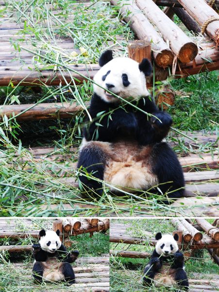
While the southwestern province of Sichuan may be celebrated for its spicy cuisine, renowned for its dynamic style of opera, and heralded as a region of unparalleled natural beauty, it is most well-known as the home of China’s cuddliest inhabitant: the giant panda. In order to protect these gentle giants, the country has taken great pains to establish a number of nature reserves and conservation centres, the most famous of which are located in the area surrounding Sichuan’s Qionglai and Jiajin Mountains. A selection of seven such nature reserves and nine scenic parks were collectively labelled a UNESCO World Heritage Site in 2006 under the title “Sichuan Giant Panda Sanctuaries”.

Altogether they cover a total area of 9,245 square kilometres (3,570 sq. mi), house over 30% of the world’s giant panda population, and represent the largest contiguous panda habitat in the world. Yet China’s beloved bear isn’t the only thing these reserves are protecting! The site acts as a refuge for a number of endangered species, including the red panda, the snow leopard, the clouded leopard, Thorold’s deer, and the Sichuan takin. Not only that but, outside of the tropical rainforests, it represents one of the botanically richest sites in the world, with over 5,000 species of plant populating its expanse. Many of these plant species play a vital role in traditional Chinese medicine and are critically endangered.

This incredible biodiversity is thanks to a delicate mixture of the site’s large altitudinal range, climate, and wide variety of soil types. From snow-capped peaks and dense forests to rippling rivers and lush alpine meadows, its diversity and scenic beauty is unmatched. The panda may not be known for its survival skills, but evidently it has great taste in real estate! The seven nature reserves make up the bulk of the site and are known respectively as Wolong National Nature Reserve, Fengtongzhai Nature Reserve, Mount Siguniang Nature Reserve, Laba River Nature Reserve, Anzihe Nature Reserve, Heishui River Nature Reserve, Jintang-Kongyu Nature Reserve, and Caopo Nature Reserve.

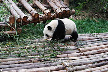
Wolong National Nature Reserve is undoubtedly the most popular and, in spite of suffering serious damage during a major earthquake in 2008, it still attracts over 100,000 visitors every year. The reserve itself was established as early as 1963 and is situated in the Qionglai Mountains region. Over 150 giant pandas call this reserve home, of which sixty-seven are captive and reside in the China Conservation and Research Centre.

Unfortunately, many environmentalists are concerned that the popularity of Wolong and the other nature reserves is actually proving to be detrimental to the conservation of the giant panda. Roads, hotels, restaurants, and shops have been built in the surrounding areas to cater to the sudden influx of tourists, and this has caused irreparable damage to the panda’s natural habitat. So, if you’re planning on visiting one of Sichuan’s magnificent nature reserves, be sure to travel responsibly and help preserve these precious gems for future generations.

Yinchuan

Yinchuan01

Flanked by the Yellow River to the east and the Helan Mountains to the west, Yinchuan is commonly known as the “land of fish and rice”, since its auspicious location provides an abundance of fertile land that is otherwise scarce in northern China. It serves as the provincial capital of the Ningxia Hui Autonomous Region, a place dominated by the Muslim Hui ethnic minority. One of its major claims to fame is that it was potentially the place where the great Genghis Khan finally died in 1227. Although no one knows exactly where this mighty Mongolian warlord breathed his last, his death and the circumstances surrounding it offer great insight into the history of this unusual city.

During the fall of the illustrious Tang Dynasty (618-907), Ningxia and several of China’s northeastern provinces were occupied by the Tangut people. After conquering this territory, they established the Western Xia Dynasty (1038-1227) and chose Yinchuan as their imperial capital. It was during the Mongolian invasion of China, when Genghis Khan was in the process of overthrowing the Western Xia Dynasty, that he met his unfortunate end, possibly in Yinchuan but most likely somewhere in Ningxia. Talk about poor timing! His grandson, Kublai Khan, went on to complete his work and eventually seized control of China proper under the Yuan Dynasty (1271-1368).

The plains surrounding Yinchuan are intensively irrigated by systems that date back to the Han (206 BC–220 AD) and Tang dynasties. From herds led by nomads on the grasslands to farms cultivating the locally famous wolfberries, it is renowned as a region of bountiful harvests and superlative agricultural products. One third of its population is made up of the Hui ethnic minority, meaning the city is littered with spectacular mosques and restaurants serving delicious traditional Hui cuisine.

Yet it’s the city’s history that has left behind the greatest treasures of all. The Western Xia Tombs, located approximately 35 kilometres (22 mi) east of the city, are one of the last known relics of this mysterious kingdom. This magnificent tomb complex is composed of over 250 separate mausoleums, nine of which belong to Western Xia kings and about 140 contain imperial family members. Taking up a total area of over 49 square kilometres (19 sq. mi), it is one of the largest and most well-preserved imperial burial sites in China. Its architecture is a hectic mixture of traditional Han Chinese, Buddhist, and Tangut features, demonstrating how these cultures intermingled in the region.

Nowadays, only two mausoleums are open to the public: the Haowang Mausoleum and the Shuang Mausoleum. However, tourists are free to wander through the complex and admire its architecture. The nearby Western Xia Museum, Western Xia Art Museum, and Western Xia Collection of Stone Inscriptions are the ideal place to learn more about the history of the site. This fascinating place represents just one of more than 60 historic sites that can be found in Yinchuan, including mosques, pagodas, pavilions, and elaborate temples.

Yinchuan Haibao TowerOf these, the most popular are the Haibao Pagoda and the Pagoda of Chengtian Temple. The eleven-storeyed Pagoda of Chengtian Temple was originally built during the Western Xia Dynasty, but was tragically destroyed and had to be rebuilt during the Qing Dynasty (1644-1912). Towering in at a height of over 64 metres (212 ft.), it is the largest pagoda in Ningxia. A wooden staircase leads to the top of the pagoda, where windows facing in four directions offer a stunning panoramic view of the city.

That being said, if you like your history with a side of glitz and glamour, you may want to consider a visit to China West Film Studio. Located at the eastern foot of the Helan Mountains just 25 kilometres (16 mi) outside of the city, it has served as the set for over 100 films, including celebrated works like Zhang Yimou’s Red Sorghum. The studio was formerly the site of two ancient castles, built during the Ming (1368-1644) and Qing dynasties respectively.

Nowadays it is separated into three areas: Qing Dynasty Town, Ming Dynasty Town, and Yinchuan Old Street. It’s is currently open to the public and offers visitors the opportunity to experience what life was like in ancient China. If you really want to get in on the action, you can even rent a traditional costume and have your photo taken in front of the beautifully crafted sets!

For nature lovers and bird-watchers alike, Sand Lake is just 56 kilometres (35 mi) north of Yinchuan and represents a bizarre wonderland of sandy desert and shimmering lakes. It is considered one of the best places in China for bird-watching, since it is home to over one million birds from 198 different species, including white cranes, black cranes, red-crowned cranes, swans, and mandarin ducks. The Bird-Watching Tower is the ideal place to enjoy a panoramic view of the scenic area and admire some of its feathered residents. Just try not to upset them, because they can be quite fowl!

Jingpo Lake

Jingpo Lake

Located deep within the Wanda Mountains of Heilongjiang province, Jingpo Lake is a shimmering gem among the ragged volcanic rocks. Its crystal clear pools, rushing waterfalls, dense forests, and volcanic landforms create a spectacular tableau, earning it the title of UNESCO Global Geopark in 2006. The name “Jingpo Lake” literally translates to mean “Mirror Lake” and is derived from a local legend, which states that it was once a mirror dropped from heaven by a goddess. While most people would incur seven years of bad luck, the goddess’ mirror instead hit the earth and transformed into a beautiful lake!

Historically speaking, the lake was actually formed about 4,700 to 8,300 years ago, when a series of five volcanic eruptions released magma that eventually cooled and dammed the upper reaches of the Mudan River. This has resulted in a somewhat unusual shape since, rather than being round or oval like a typical lake, Jingpo Lake maintains the original shape of its watercourse and resembles an S-shaped ribbon. It is divided into four parts, Upper Lake, North Lake, Middle Lake, and South Lake, and is often referred to as the “100-Li Long Lake” because it stretches for a distance of approximately 100 li[1] (48 km or 30 mi).

Its turquoise-hued waters, speckled with freshwater coral, harbour over 40 species of fish. Every year, from December through to March, the Jingpo Lake Ice Fishing Festival offers visitors the opportunity to attend a worshipping ceremony for the Lord of the Lake, test their skill at fishing, and sample some of the finest local fish dishes. With such tempting treats on offer, any seafood lover should make sure to catch this festival!

Jingpo Lake 01At the lake’s northern end, you’ll find the scenic area’s star attraction: Diaoshuilou Waterfall. Dropping for over 20 metres (66 ft.) and with a width of over 40 metres (130 ft.), it is one of the widest waterfalls in Asia and is said to resemble Niagara Falls in its grandeur. If that wasn’t impressive enough, every day the park holds two performances where a professional diver jumps from the top of the waterfall and deftly dives into the 60-metre (200 ft.) deep pool below.

Towards the northwest of the lake, twelve volcanic craters are scattered among the dense forests of the scenic area. These lush forests act as habitats for over 50 species of wild mammal and more than 500 kinds of wild bird. Under these volcanic plateaus, you’ll find spectacularly eerie lava tunnels, some of which are over 10,000 metres (32,800 ft.) long. They are some of the largest and most intact lava tunnels in China, earning the region the nickname the “Underground Forest”.

Yet natural delights aren’t the only thing on the menu at Jingpo Lake. The area is also home to numerous historical sites from the Korean Balhae Kingdom (698–926). During the Tang Dynasty (618-907), the Balhae Kingdom ruled over large parts of northeast China and, in many ways, sought to imitate the highly successful Tang regime. Shanjing Longquanfu, an ancient imperial city located just 20 kilometres (12 mi) north of Jingpo Lake, was designed based on the pattern of Chang’an (modern-day Xi’an), the Tang imperial capital. The city walls and main buildings of the imperial palaces have been preserved intact, and remain a popular tourist destination.

The 1,200-year-old Xinglong Temple, another relic of the Balhae Kingdom, is now used to house valuable cultural artefacts found in the region. The most famous of these is the Stone Lamppost, a Buddhist stone carving that exemplifies the sculptural style of both the Tang Dynasty and the Balhae Kingdom. Aside from its natural beauty and historical significance, Jingpo Lake has a space-age claim to fame! A large surface body of liquid hydrocarbons on Titan, the largest moon orbiting planet Saturn, was named Jingpo Lacus in its honour. In other words, you could say that this lake has astronomical appeal!

[1] Li: A unit of distance used in China that roughly equates to 500 metres (1,640 ft.).