Covering a colossal area of 22,900 square kilometres (8,842 sq. mi), the Kumtag Desert spans from Ruoqiang County in Xinjiang to the city of Dunhuang in Gansu province, and forms the eastern section of the much larger Taklamakan Desert. In the language of the Uyghur people, the word “kum-tag” means “sand-mountain” and refers to the looming dunes that populate this barren expanse. The desert itself was formed over a period of centuries, as a result of strong winds colliding and depositing the masses of sand they were carrying in unusual formations.
Sand dunes within the desert can rise to heights of up to 76 metres (250 ft.), making them taller than the Leaning Tower of Pisa! While the region is resplendent with these natural monoliths, it’s also home to a number of magnificent sand statues that have been crafted by local artisans. Lifelike figures, towering fortresses, and miniature sand cities rise up in its barren expanse, creating a dazzling fairy-tale world. Riding camels through the baking hot desert, you’ll be transported back to life as a traveling merchant on the ancient Silk Road.
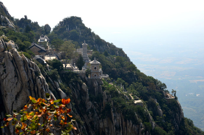
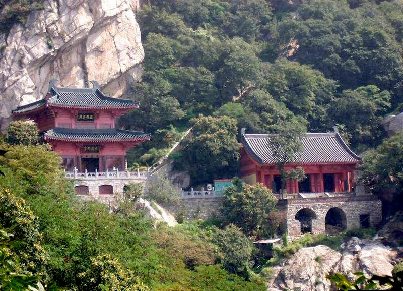
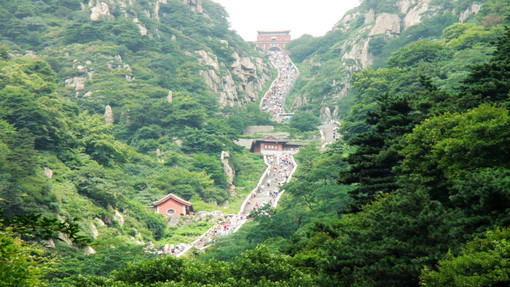
Rising up at the heart of Henan province, Mount Song ranks as one of the Five Great Mountains of China. Its location in relation to the other five mountains means it is often referred to as Zhongyue or the “Central Mountain”. These mountains are known simply as the Five Great Mountains or the Five Great Sacred Mountains because they achieved a profoundly spiritual status during the Warring States Period (c. 476-221 BC), long before Confucianism, Taoism, or Buddhism had taken an important role in Chinese religious belief. In many ways, the mysticism imbued within these mountains pre-dates modern religion, and they unsurprisingly remain a source of fascination for tourists from across the globe.
The mountain range itself rests just outside of the city of Dengfeng, approximately 80 kilometres (50 mi) from the provincial capital of Zhengzhou, and can be separated into two major peaks: Mount Shaoshi and Mount Taishi. In total, it stretches for a whopping 70 kilometres (43 mi) from east to west and is made up of 72 separate peaks, with its summit towering in at 1,500 metres (4,900 ft.) in height. When it comes to tourism, the range has been conveniently divided into three sections: the Shaolin Temple Scenic Area, home of the Shaolin Temple; the Zhongyue Scenic Area, named after the ancient Zhongyue Temple; and the Songyang Scenic Area, where you’ll find Songyang Academy.
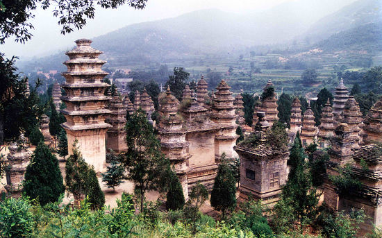
Altogether they represent a wonderland of lush valleys, deep caves, shimmering lakes, rippling waterfalls, and historic temple complexes. Arguably the most famous of these is the 1,500-year-old Shaolin Temple, which is dedicated to the Chan (Zen) sect of Buddhism and heralded as the birthplace of Shaolin Kung-Fu. The colossal impact that this temple has had on the history of Buddhism and martial arts meant it was designated a UNESCO World Heritage Site in 2010, along with the nearby Pagoda Forest. Nowadays, martial artists and tourists from all walks of life flock to the temple to admire its elegant buildings and marvel at its daily Wushu Kung-Fu performances.
The Pagoda Forest itself is equally as impressive, being the largest of its kind in China. It contains over 240 intricately decorated towers, all of different shapes and sizes, the oldest of which date all the way back to the Tang Dynasty (618-907). Yet the name “Pagoda Forest” can be somewhat misleading, since it is not a forest and the buildings aren’t actually pagodas! They are more like tombs or monuments, since each one was constructed to commemorate the death of an abbot or famous monk from the Shaolin Temple.
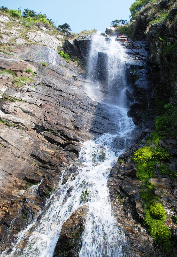
Zhongyue Temple in the Zhongyue Scenic Area carries a similar, if not more remarkable, historical pedigree. Dating all the way back to the Qin Dynasty (221-206 BC), it is one of the oldest Taoist temples in China and is largely regarded as the most well-preserved ancient building among any on the Five Great Mountains. However, the scenic area is also home to two lesser-known delights: the Luya Waterfall and the Gaocheng Astronomical Observatory. The Astronomical Observatory was originally built by the astronomer Guo Shoujing during the Yuan Dynasty (1271-1368) and, at the stately age of 700 years, it is the oldest of its kind in China. It serves as living proof that, even in ancient times, people would still look to the stars for guidance!
As with the other two scenic areas, the Songyang Scenic Area is centred on an ancient building of undeniable prestige. Dating back to the Northern Wei Dynasty (386–535), the Songyang Academy is heralded as one of the Four Great Academies of ancient China. Famous Confucian scholars such as Sima Guang and Cheng Yi would travel for miles simply to give lectures at this venerable establishment. At its height during the Qing Dynasty (1644-1912), it housed hundreds of students and boasted a library complete with over 2,000 books! The nearby Songyue Pagoda, which was also built during the Northern Wei Dynasty, is the oldest surviving brick pagoda in China.
If you want to fully appreciate all of the wonderful attractions that Mount Song has to offer, you’ll need to set aside at least two days for in-depth exploration. There are a number of small towns in the surrounding area offering accommodation and, to the west of the Shaolin Temple, there is even a village embedded halfway up a cliff! The village of Sanhuang has become famous for its precarious position, and is a popular rest stop for hikers traveling up the mountain. Just be sure not to look down!
From singing sand dunes to unexplained lakes, the Badain Jaran Desert is marked by its mysterious natural wonders. It stretches across Inner Mongolia, Ningxia, and Gansu province and covers a colossal area of 49,000 square kilometres (19,000 sq. mi). Although it is considered part of the Gobi Desert, as an independent entity it technically ranks as the third largest desert in China. To the east, it is separated from the Ulan Buh Desert by Mount Lang, and only Mount Yabulai stands between it and the Tengger Desert to the southeast. To the southwest lies the famed Hexi Corridor, a major section of the ancient Silk Road; and to the west flows the Ejin River, which cuts it off from the hostile Taklamakan Desert.
While deserts are not typically known for their habitability, archaeological findings suggest that the Badain Jaran Desert was inhabited or at least ventured into by people from as early as the Paleolithic Era (roughly 2.6 million to 10,000 years ago)! During the Xia Dynasty (c. 2100-1600 BC), the area was settled by the Tangut people, who were known to have traded with merchants from the ancient region of Bactria (2200-1700 BC) in Central Asia. Nowadays the desert is a popular tourist attraction, with visitors flocking to marvel at its myriad of natural oddities.
The Badain Jaran Desert boasts some of the tallest stationary dunes on earth, with most of them averaging at around 200 metres (660 ft.) and some of them reaching over 400 metres (1,300 ft.) in height. Most of the dunes are not stationary, but the ones that are still have a shallow layer of sand at the top that is constantly shifting. It is the middle and lower layers of these dunes that remain static, as the sand in these layers has been compacted over a period of more than 20,000 years. This has caused the sand particles to harden, eventually transforming them into solid sand or sandstone.
The desert’s largest stationary sand dune, known as Bilutu Peak, towers in at a height of 500 metres (1,600 ft.) from base to peak, making it the tallest sand dune in Asia and the tallest stationary sand dune in the world. To put that into perspective, Bilutu Peak is over 50 metres (164 ft.) taller than the Empire State Building! While the size of the sand dunes is undoubtedly impressive, it is their capacity to sing that attracts tourists from across the globe. Often referred to as the singing sand dunes, whistling sands, or booming dunes, this fantastical phenomenon is shared by only 35 other beaches and deserts around the world.
For reasons that are not entirely known, the dunes emit a low pitched rumbling sound that can reach over 105 decibels and last for more than a minute. It is believed that the noise is caused by the electrostatic charge generated when wind pulls the top layer of shifting sand down the dune slope. However, it will only occur under very specific circumstances. The dunes are eerily silent during the winter, when the sand retains moisture from the rain. Even in the summer, this booming sound can only be generated on the leeward face of a dune with a slope that rises at an angle of at least 60 degrees or more. Although the booming dunes might be seasonal, it is possible to make the dunes burp all year round! By moving your hand gently through the dry sand of a booming sand dune, you can destabilise the upper layer of sand and cause it to emit a brief “burping” sound.
Between these sand dunes lies another of the desert’s strange secrets: over 140 colourful lakes scattered throughout its sandy expanse. These lakes are typically found in the valleys formed between the larger sand dunes and provide sustenance to the numerous camels, goats, and horses that are herded through the desert by nomads. Around many of the lakes, a green ring of vegetation sits in stark contrast to the barren desert that surrounds it. Some are freshwater lakes, while others are extremely salty. Large populations of brine shrimp, algae, and certain minerals cause some of the lakes to change colour at different times of the year.
It is believed that the lakes are formed from melted snow and spring water that trickles down from the nearby mountains and runs under the desert in underground streams, although the true source of the lake water has yet to be found. On the southeastern margin of the desert, the lakes are long and shallow, reaching depths of less than 2 metres (6 ft.). These lakes have a much lower salt concentration than the deeper oval-shaped lakes found further in, which can reach maximum depths of up to 15 metres (49 ft.).
These verdant oases in the otherwise desolate desert have allowed more than just plant life to flourish. Situated on the banks of a lake in the middle of the desert, the Badain Jaran Temple has been a centre for Tibetan Buddhism since it was built in 1868. Its isolated location means it has been untouched by the warfare and unrest that typically plagued other temples in China. Elaborate statues, wood carvings, relics, and a small white pagoda have all been beautifully preserved within this ancient temple complex.
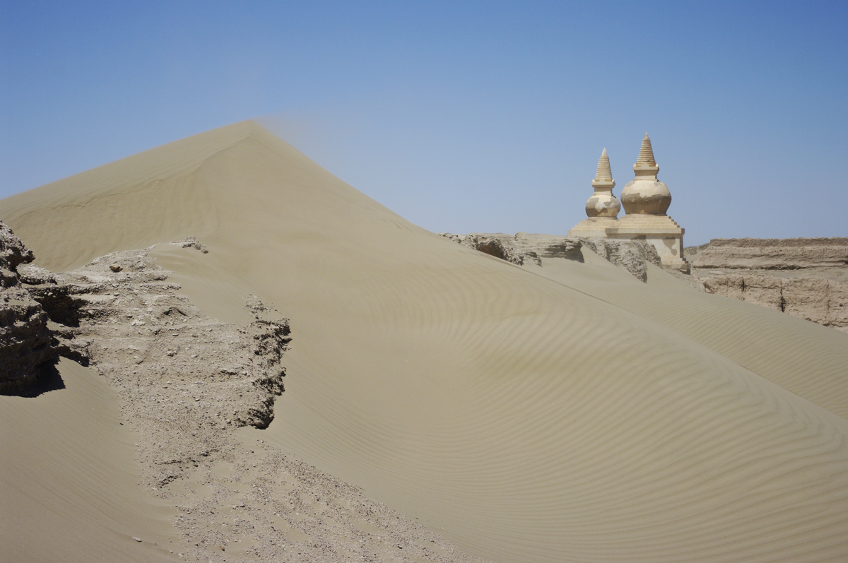
On the northwestern edge of the desert lies the Ejin Banner, which once served as the hunting grounds of the fearsome Xiongnu people until the region was conquered by the Han Dynasty (206 BC–220 AD) in 121 BC. Nowadays its population is predominantly Han Chinese, but it is still regarded as a culturally Mongolian region. Within its vast expanse lie the ruins of Khara-Khoto, an ancient metropolis that was built by the Tangut people of the Western Xia Dynasty (1038–1227) and rose to become a major trading hub during the 11th century.
The unusual terrain in the Badain Jaran Desert means that these attractions can only be reached by hiring a special jeep. Unlike other vehicles, these jeeps are designed to drive on sand, and are capable of ascending and descending the sand dunes. The climate in the Badain Jaran Desert oscillates between the temperate arid and the extremely arid, so it is of paramount importance to be prepared on your travels. Temperatures can rise to a sweltering 41 °C (106 °F) during the day and plummet to −30 °C (−22 °F) at night. When the sun is at its hottest, sand temperatures can easily exceed 80 °C (176 °F), so be sure to don appropriate footwear. In short, choose boots that were made for walking, not melting!
Rising up mistily in the countryside of Jiangxi province, Mount Lu was once one of the major cultural and spiritual centres of ancient China. In fact, its undeniable historical significance meant that it was honoured as a World Heritage Site by UNESCO in 1996. Located approximately 20 kilometres (12 mi) south of Jiujiang City in the northern part of Jiangxi province, it forms the eastern extremity of the Mufu Mountains and culminates in the 1,474 metre (4,836 ft.) tall Dahanyang Peak. To the north, it offers spectacular views of the Yangtze River, while to the south it overlooks the shimmering Lake Poyang.
In ancient times, this mountain range was known as Mount Kuanglu and was regarded as a holy place. As early as the Han Dynasty (206 BC–220 AD), a prominent Taoist priest named Zhang Daoling travelled to the mountain in order to worship there. During the Jin Dynasty (265-420), the Donglin or “Eastern Wood” Temple was established on the mountain’s northern slope by a celebrated monk named Huiyuan, who founded the Pure Land Sect of Buddhism. From then on, numerous temples dedicated to Buddhism and Taoism began cropping up across the mountain, until there were over 300 of them. Talk about prime spiritual real estate!
Arguably the mountain’s greatest claim to fame is the White Deer Grotto Academy at the base of Five Old Men Peak, named for its supposed resemblance to five old men sat side-by-side. The academy was originally established during the Tang Dynasty (618-907) by the poet Li Bo and was so-called because he kept a white deer as a pet. However, it didn’t become truly famous until the Song Dynasty (960-1279), when it was revived by a celebrated philosopher named Zhu Xi.
Zhu was the founder of Neo-Confucianism, which is widely regarded as one of the most influential schools of thought in Chinese history. Thanks to his efforts, the academy rose to prominence as one of the Four Great Academies of China and, by the 19th century, it had expanded into a colossal complex, complete with its own temples, study halls, and libraries. Over time, countless writers, artists, and calligraphers have sung the mountain’s praises, immortalising it in over 900 cliff inscriptions and more than 300 steles[1] that can be found throughout the range.
Before the Second World War, Mount Lu became the official Summer Capital of the Republic of China (1912-1949) and was a popular retreat for expats throughout the country. Chiang Kai-shek, leader of the Kuomintang[2], would often spend his summers there and it became the setting for a number of major political events, including in 1937 when Chiang announced his intention to fully mobilise for war against the Japanese and in 1946 when he met with the US General George C. Marshall. The mountain continued to play a major political role in Communist China, when Mao Zedong led three large meetings in 1959, 1961, and 1970 known as the Lushan (Mount Lu) Conferences.
Nowadays, with its beautiful scenery and elegant temples, the mountain range is a popular tourist attraction. Geographically speaking, it’s known as a horst-style block mountain, meaning it’s a narrow section of land that lies between two fault lines and has been pushed up as a result of tectonic pressure from either side. Scattered throughout its expanse, you’ll find rippling streams, deep ravines, rocky outcroppings, mysterious caves, and rushing waterfalls.
Of the mountain’s 12 main scenic areas and 37 attractions, the Three Step Waterfall is undoubtedly one of the most magnificent. On its way down, the waterfall spills over three natural, glaciation-formed terraces and drops approximately 155 metres (509 ft.). It’s considered so integral to the mountain range that an old local saying states a visit to Mount Lu would be wasted if you missed seeing the Three Step Waterfall. After all, three is the magic number!
Hanpo Pavilion, which is located at the top of Hanpo Pass, is the ideal place to enjoy a panoramic view of the entire area surrounding the mountain. Marvel at aerial views of Lake Poyang glistening in the sunlight or absorb the breath-taking vistas of the peaks as the sun slowly rises behind them. If you fancy staying on the mountain to ensure you capture the beauty of the sunrise, there’s a village located at the heart of the mountain range known as Guling. The village’s name, which translates to mean “bull”, is derived from the fact that its layout supposedly resembles the shape of a bull. After a long hike up the mountain, nothing is sure to relax you more than a cup of locally grown Yunwu tea in one of the village teahouses!
[1] Stele: An upright stone slab or pillar that bears an inscription and usually marks a burial site, like a tombstone.
[2] Kuomintang: Also known as the Chinese Nationalist Party. They were the ruling party from 1928 until their defeat at the hands of the Communists in 1949. They retreated to Taiwan, where they still play an active political role.
Located deep within the Wanda Mountains of Heilongjiang province, Jingpo Lake is a shimmering gem among the ragged volcanic rocks. Its crystal clear pools, rushing waterfalls, dense forests, and volcanic landforms create a spectacular tableau, earning it the title of UNESCO Global Geopark in 2006. The name “Jingpo Lake” literally translates to mean “Mirror Lake” and is derived from a local legend, which states that it was once a mirror dropped from heaven by a goddess. While most people would incur seven years of bad luck, the goddess’ mirror instead hit the earth and transformed into a beautiful lake!
Historically speaking, the lake was actually formed about 4,700 to 8,300 years ago, when a series of five volcanic eruptions released magma that eventually cooled and dammed the upper reaches of the Mudan River. This has resulted in a somewhat unusual shape since, rather than being round or oval like a typical lake, Jingpo Lake maintains the original shape of its watercourse and resembles an S-shaped ribbon. It is divided into four parts, Upper Lake, North Lake, Middle Lake, and South Lake, and is often referred to as the “100-Li Long Lake” because it stretches for a distance of approximately 100 li[1](48 km or 30 mi).
Its turquoise-hued waters, speckled with freshwater coral, harbour over 40 species of fish. Every year, from December through to March, the Jingpo Lake Ice Fishing Festival offers visitors the opportunity to attend a worshipping ceremony for the Lord of the Lake, test their skill at fishing, and sample some of the finest local fish dishes. With such tempting treats on offer, any seafood lover should make sure to catch this festival!
At the lake’s northern end, you’ll find the scenic area’s star attraction: Diaoshuilou Waterfall. Dropping for over 20 metres (66 ft.) and with a width of over 40 metres (130 ft.), it is one of the widest waterfalls in Asia and is said to resemble Niagara Falls in its grandeur. If that wasn’t impressive enough, every day the park holds two performances where a professional diver jumps from the top of the waterfall and deftly dives into the 60-metre (200 ft.) deep pool below.
Towards the northwest of the lake, twelve volcanic craters are scattered among the dense forests of the scenic area. These lush forests act as habitats for over 50 species of wild mammal and more than 500 kinds of wild bird. Under these volcanic plateaus, you’ll find spectacularly eerie lava tunnels, some of which are over 10,000 metres (32,800 ft.) long. They are some of the largest and most intact lava tunnels in China, earning the region the nickname the “Underground Forest”.
Yet natural delights aren’t the only thing on the menu at Jingpo Lake. The area is also home to numerous historical sites from the Korean Balhae Kingdom (698–926). During the Tang Dynasty (618-907), the Balhae Kingdom ruled over large parts of northeast China and, in many ways, sought to imitate the highly successful Tang regime. Shanjing Longquanfu, an ancient imperial city located just 20 kilometres (12 mi) north of Jingpo Lake, was designed based on the pattern of Chang’an (modern-day Xi’an), the Tang imperial capital. The city walls and main buildings of the imperial palaces have been preserved intact, and remain a popular tourist destination.
The 1,200-year-old Xinglong Temple, another relic of the Balhae Kingdom, is now used to house valuable cultural artefacts found in the region. The most famous of these is the Stone Lamppost, a Buddhist stone carving that exemplifies the sculptural style of both the Tang Dynasty and the Balhae Kingdom. Aside from its natural beauty and historical significance, Jingpo Lake has a space-age claim to fame! A large surface body of liquid hydrocarbons on Titan, the largest moon orbiting planet Saturn, was named Jingpo Lacus in its honour. In other words, you could say that this lake has astronomical appeal!
[1]Li: A unit of distance used in China that roughly equates to 500 metres (1,640 ft.).
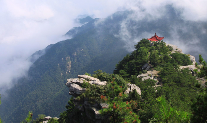
Through misty climes and dense forests the emperors of old would navigate Mount Tai, making the harrowing climb in order to offer sacrifices to the gods. For nearly 3,000 years, it has been a hallowed and sacred place. As the Eastern Mountain of China’s Five Great Mountains, it is often regarded as the foremost of the five. East was believed to be the holiest point since it was the direction from which the sun and the moon would rise, leading it to be associated with birth and renewal. There is even an old Chinese proverb which states: “If Mount Tai is stable, so is the entire country”. While the mountain range’s natural beauty is undeniable, its cultural importance is immeasurable. As early as 1987, it was designated a UNESCO World Heritage Site.
Archaeological evidence from the nearby Dawenkou site indicates that the area was settled and may have been a place of worship as early as the Neolithic Period (c. 8500-2100 BC). By the Shang Dynasty (c. 1600-1046 BC), it was firmly believed to be the home of powerful spirits that could influence the weather, the harvest, and the prosperity of any hopeful dynasty. However, it wasn’t until the Zhou Dynasty (c. 1045-256 BC) that it became the site of highly ritualised ceremonies, during which feudal lords would make sacrifices of food and decorative jade items. Many of these sacrifices would be buried on the mountain, so be sure to keep your eye out for any precious artefacts whilst you’re hiking!
These rituals reached a peak during the Qin Dynasty (221-206 BC), when Qin Shi Huang conquered the warring states and became the First Emperor of a unified China. In 219 BC, he held a ceremony on the mountain’s summit where he proclaimed the unity of his empire. He paid tribute to Mount Tai using an imperial rite known as the Fengshan sacrifices. The “feng” or “heaven” part of the rite would take place on the summit, while the “shan” or “earth” portion would be made at the base. In this way, the emperor paid homage to both heaven and earth in what was considered one of the most important imperial rituals in history. At the end of the ceremony, an inscription would be carved marking the event and the supposed attainment of the “great peace”.
By the Han Dynasty (206 BC–220 AD), Mount Tai was so highly regarded that it was believed to be the place where the souls of the deceased returned for judgement. Yet, in spite of the mountain’s significance, the Fengshan ritual was carried out at very rare intervals. From the Han Dynasty to the Tang Dynasty (618-907), it was only performed on seven separate occasions. After all, mountain climbing may seem hard now, but imagine trying to do it over a thousand years before the invention of hiking boots! Emperors would have to climb a flight of 6,660 steps, which winds its way passed fourteen archways and four pavilions, all decked out in traditional Chinese grandeur and seamlessly incorporated into the natural landscape. The summit itself is known as Jade Emperor Peak and is a breath-taking 1,545 metres (5,069 ft.) tall.
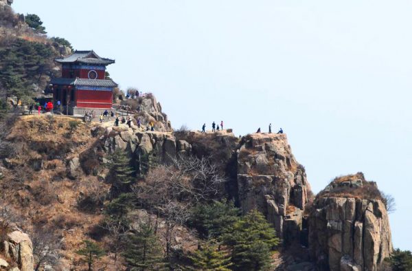
As time went on, Mount Tai’s holiness manifested not only in the imperial inscriptions, but also in a collection of 1,800 stone tablets and 22 temples that can be found throughout the mountain range today. Most famous of these is the Dai Temple at the southern foot of the mountain, which is dedicated to the God of Mount Tai and was originally built during the Qin Dynasty. Its architecture is largely considered to be a prototype of the imperial palace style and its design greatly influenced the construction of other major palace structures in China, such as the Forbidden City in Beijing and the Confucius Temple in Qufu.
The temple itself is made up of five major halls and numerous satellite buildings. Its star attraction is a Taoist painting known as “The God of Mount Tai Making a Journey”, which was completed in 1009 and is widely regarded as a masterpiece of traditional Chinese art. This epic mural is over 3 metres (10 ft.) high and 62 metres (203 ft.) long, extending across the eastern, western, and northern walls of the Palace of Heavenly Blessings. This makes it roughly the same height as an African elephant and approximately 15 times the length of an anaconda!
While the God of Mount Tai was arguably the mountain’s central spiritual figure in early Chinese history, he was swiftly overtaken in popularity during the Ming Dynasty (1368-1644) by his daughter, the Lady of Mount Tai. She is often known by her alternate name of Bixia Yunjun or “Goddess of the Colourful Clouds” and the Azure Cloud Temple was erected in her honour during the Song Dynasty (960-1279).
Both of these temple complexes boast a myriad of ancient trees, which attest to the intermingling of man-made and natural elements on Mount Tai. In particular, there is one pagoda tree that is approximately 1,300 years old, and six cypresses that are over 2,000 years of age! With 72 caves, 130 streams, 72 springs, and a staggering 64 waterfalls, Mount Tai is a paradise for nature lovers. After spending a day hiking up its verdant slopes, you’ll understand why ancient people believed it was blessed by the gods!
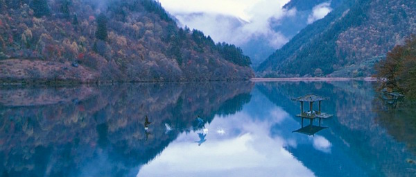
Jiuzhaigou, the Valley of the Nine Fortified Villages, is a place as ethereal as its name suggests. This national park stretches over 720 square kilometres (278 sq. mi) of raw nature nestled deep within northern Sichuan province. As part of the Min Mountains, this reserve is renowned for its snow-capped peaks, dense forests, thundering waterfalls, and richly coloured lakes. Its superlative scenic beauty and unparalleled biodiversity meant it was designated a UNESCO World Heritage Site in 1992 and a UNESCO World Biosphere Reserve in 1997. In short, this unearthly paradise earned more accolades in five years than most people get in their lifetime!
The park is located approximately 913 kilometres (567 mi) from the provincial capital of Chengdu, and is so-named for the nine villages that run along the length of its main valleys. Only seven of the nine remain populated today, and are known as Heye, Shuzheng, Zechawa, Rexi, Jianpan, Panya, and Yana. They are home to both the Tibetan and Qiang ethnic minorities, who have inhabited the region for centuries and consider many of the scenic spots in the park to be holy.
Within their rich tapestry of folklore, many fascinating legends surround the mountains, woods, and pools that can be found throughout the park. According to one such Tibetan legend, the warlord god Dage was madly in love with the goddess Wunosemo, and so presented her with a beautiful magic mirror as a gift. However, one day, a jealous devil caused the goddess to drop the mirror to earth, where it shattered to form the 114 shimmering lakes that are considered the highlight of Jiuzhaigou.
Scientifically speaking, much of the park’s gullies and mountains were formed thanks to tectonic activity between the Qinghai-Tibet Plate and the Yangtze Plate, since it lies along the plates’ major fault-lines. It is constituted of three main valleys, Shuzheng, Rize, and Zechawa, which are arranged in a formation that resembles the letter Y. Its expanse is populated by a number of endangered animal species, including the giant panda, the golden snub-nosed monkey, Thorold’s deer, and the Duke of Bedford’s vole. Although you’re unlikely to come face-to-face with a bashful panda, you’re sure to spot one of the park’s 140 native bird species, as the area is a haven for bird-watching.
Jiuzhaigou’s fowls may be fair, but they’re nothing compared to the park’s star attractions: the blue, green, and turquoise-coloured lakes that are dotted throughout its valleys. Many of them were originally formed by glacial activity, but then dammed by falling rocks. Some of them have a high concentration of calcium carbonate, which results in them being so crystal clear that their bottoms are visible even at high depths. Their rich colouring and unmatched transparency make them undoubtedly some of the most breath-taking bodies of water in the world.
The Film ‘Hero’
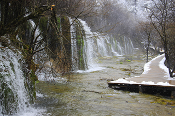
It is recommended to visit the park during autumn, when the pools are at their most translucent and perfectly reflect the rich golden hues of the autumnal foliage. Rize Valley is said to contain the widest variety of sites, and so is typically visited first. The Primeval Forest, a stretch of ancient woodland that has been preserved for centuries, offers stunning views of the surrounding mountains, while you may recognise Arrow Bamboo Lake as the set of the martial arts epic Hero.
Pearl Shoal is the source of the magnificent Pearl Shoal Falls, which are said to look like a string of pearls cascading down the mountainside. Cyan-hued Panda Lake is reputedly the place where local pandas come to drink and empties out via the Panda Falls into Five Flower Lake, Rize Valley’s star attraction, which is so piercingly clear that you can still see the ancient trunks of fallen trees floating in its turquoise waters.
Second on the itinerary is usually Zechawa Valley, which is approximately the same length but rises to a higher altitude. It boasts the crescent-shaped Long Lake, the highest, largest, and deepest lake in Jiuzhaigou. According to local folklore, a monster supposedly haunts its depths, so be sure to keep an eye out when standing by its banks! The valley’s mythical status doesn’t end there, as its shimmering Five-Colour Pond was rumoured to be the place where the goddess Wunosemo would wash her hair.
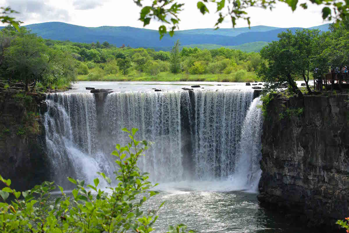
Not to be outdone, Shuzheng Valley possesses a number of legendary sites, although their origin stories are slightly less magical. For example, the largest lake in the valley, Rhinoceros Lake, was reputedly so-named because a Tibetan monk was once riding his rhinoceros through the valley when he became so entranced by the area’s beautiful scenery that he accidentally rode his rhinoceros directly into the lake! Perhaps he was distracted by the glorious Nuorilang Falls, the widest highland waterfall in China and one of the icons of Jiuzhaigou.
However, if you want to really connect with the spirituality of Jiuzhaigou, you’ll need to visit Zharu Valley, which branches off to the southeast of Shuzheng Valley. Its main hike follows the pilgrimage path of the local Tibetan Buddhists, who circumnavigate the sacred Zha Yi Zha Ga Mountain as part of a religious ritual. The hike offers stunning panoramic views of the natural scenery, a chance to learn more about Jiuzhaigou’s unique biodiversity, and an insight into its fascinating local culture.
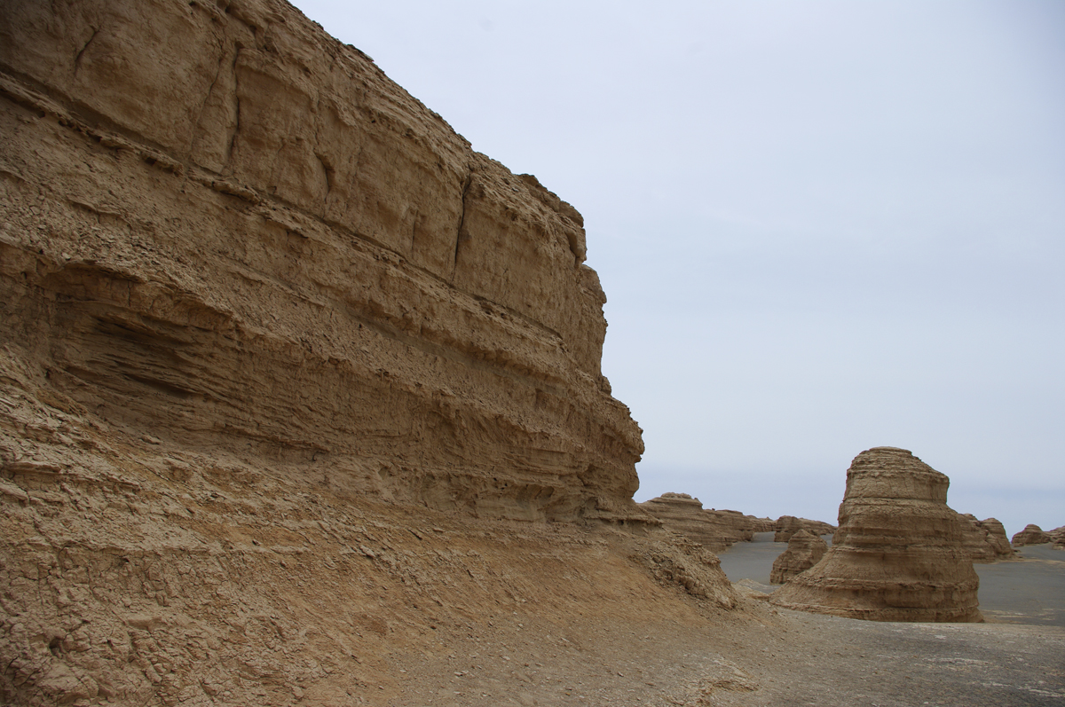
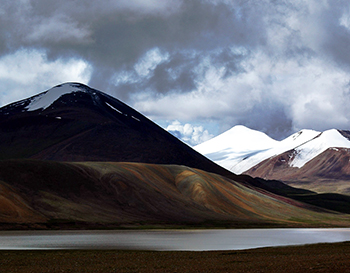
The snowy Kunlun Mountains stretch 2,000 kilometres (1,250 mi) from the far reaches of the Pamirs in Tajikistan through to the centre of Qinghai province in China and represent one of the longest mountain chains in Asia. They tower along the border between Xinjiang and the Tibet Autonomous Region and, at their westernmost point, form the Inner Asian rampart between the Tibetan Plateau and the Tarim Basin. At the southern edge of the Takla Makan Desert, these snowy mountains form a protective barrier against the icy expanses of Tibet and appear strangely beautiful surrounded by the soft golden sands. This range is so colossal that it branches off into several other mountain ranges, including the Altun Mountains and the Qilian Mountains. Unsurprisingly this has earned it the nickname the “Forefather of Mountains”.
The highest peak of the range, Mount Keriya, can be found in Yutian County of Xinjiang and sits at a staggering elevation of 7,120 metres (23,300 ft.), making it over 1,000 metres (3,300 ft.) higher than Mount Kilimanjaro! Unfortunately this high altitude and the desert conditions that prevail throughout the range largely inhibit the growth of vegetation and make the area virtually uninhabitable. Or so it would seem!
Much of the terrain consists of rock deserts, punctuated only by the occasional stagnant pool of water. Not exactly the most welcoming sounding place! Yet a number of rare animal species still manage to scrape a living in these barren wastes, including the Tibetan gazelle, Tibetan antelope, and wild yak. In the more humid and hospitable western portion of the mountains, argali sheep graze on the high grasslands and the upper crags are home to blue sheep and ibex. The willow thickets provide the perfect habitat for brown bears, wolves, and the occasional snow leopard, so don’t tread through them lightly!
In fact, the animals aren’t the only ones making a home out of this seemingly desolate place. The mountain range supports both permanent and migratory populations of people from the Uighur, Mongol, Tibetan, Tajik, and Kyrgyz ethnic minorities, as well as large constituencies of Han people. This is evidenced by settlements around the Kunlun Mountain Pass, just 160 kilometres south of Golmud City, which once made up part of the Silk Road.
It is an obligatory section on the route between Qinghai and Tibet and represents a sudden rise in altitude from 2,800 metres to 4,700 metres (9,200-15,400 ft.). The temperature and air pressure drop rapidly as you ascend, so this hike isn’t for the faint of heart. It has also enjoyed great fame for the stunning Kunlun Jade, which is predominantly mined here.
The mysticism surrounding this mountain range is undeniable and it has featured in numerous Chinese folk legends, including those of Chang’e (the goddess of the moon), Journey to the West, and The Legend of the White Snake. In other legends, it was believed to be the origin or father of all mountains. That being said, it is unclear whether the Kunlun Mountains were named after the legendary Kunlun Mountain of Chinese mythology or whether they are believed to be the site of the Kunlun Mountain itself.
In terms of the Taoist faith, these mountains are incredibly sacred and, according to legend, were first visited by King Mu (976-922 BC) of the Zhou Dynasty (c. 1045-256 B.C). It was here that he supposedly discovered the location of the Jade Palace, where the mythical Huang Di or “Yellow Emperor” lived, and met the Queen Mother of the West, who was the focal figure of an ancient religious cult that peaked during the Han Dynasty (206 BC–220 AD).
The Taoist connection to the mountains has led to a style of kung-fu known as Kunlun Mountain Fist being associated with it, although it bears great similarity to another style called Kunlunquan that originated from Kunlun Mountain in Shandong province. Its history can be traced all the way back to the Zhou Dynasty and it is one of the few Taoist sects of martial arts where students of both genders are accepted and members are allowed to marry. So in short, don’t mess with any of the married couples around the Kunlun Mountains!
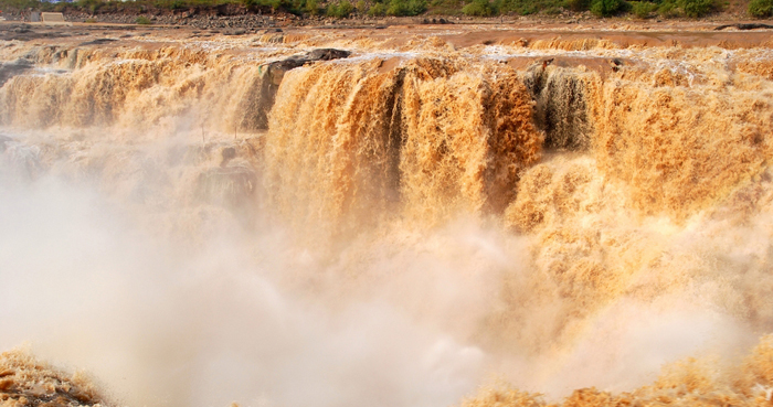
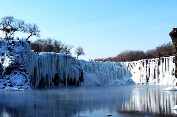
Ranking just after the Huangguoshu Waterfall, the Hukou Waterfall is the second largest waterfall in China and the only yellow waterfall in the world. Yet there’s nothing yellow-bellied about this powerful natural phenomenon! It rests at a point along the Yellow River where the riverbed suddenly tapers down from 300 metres (984 ft.) to 50 metres (164 ft.), transforming tranquil waters into cascading rapids. The result is a magnificent 15 metre-high (49 ft.) and 20 metre-wide (66 ft.) waterfall that gushes down from the narrow opening like bubbling water pouring from a teapot. This is what earned the waterfall its unusual name, as “hukou” literally translates to mean “a spout” in Chinese. That being said, don’t go trying to pour yourself a cuppa from this fierce torrent!
The waterfall is located at the intersection between the provinces of Shanxi and Shaanxi, about 165 kilometres (103 mi) west of Fenxi City and 50 kilometres (31 mi) east of Yichuan County. The provinces are in fact connected by Qilangwo Bridge, which spans the stretch of river just beneath the waterfall. The waterfall itself can be found within Jinxia Grand Canyon and is flanked on both sides by Hukou Mountain. Its size and velocity changes depending on the season, and can easily reach a staggering 50 metres (164 ft.) in width during the rainy season. In winter, it’s said to be particularly beautiful as the water slows and the riverbed is lined by shimmering icicles.
According to the locals, the thundering sound of the water can be heard for miles around, and the current is so strong that boats have to be pulled out of the river long before they even get to the waterfall. These boats have to either be shipped by truck or carried around this section of the river before they can be put back in the water. So, while the Hukou Waterfall might float your boat metaphorically, the harsh reality is it’s far more likely to sink it in real life!
Just below the waterfall, be sure to look out for a shining stone that the locals call the guishi or “ghost stone”. Rumour has it that this mysterious stone moves up and down depending on the water level and, no matter how high the water is, it’s always partly visible. It might not be the stuff of horror films, but it’s certainly pretty unique!
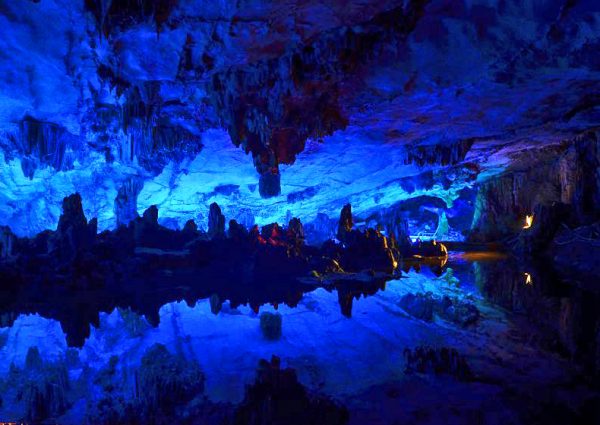
Reed Flute Cave (Ludi Yan) earned its unusual name thanks to the plentiful reeds growing outside of the cave’s entrance that are often used to make flutes or other small wind instruments. The cave is about 5 kilometres northwest of downtown Guilin and the main entrance to the cave is situated on the south side of Guangming Hill or “Bright Light” Hill. Reed Flute Cave is a natural limestone cave that has formed over a period of 180 million years. Although it was only officially opened as a tourist attraction in 1962, it has in fact been a tourist site for over 1,200 years. As a testament to its popularity throughout the years, more than 70 inscriptions have been written in ink on the cave’s walls, some of them dating all the way back to 792 A.D. These inscriptions are evidence that the cave has been a beloved attraction since the Tang Dynasty (618-907).
For many years, the cave remained untouched until, in the 1940s, a group of Chinese refugees fleeing from Japanese troops during World War II came upon the cave and used it as a hiding place. The cave itself is 240 metres long and boasts a glittering array of stalagmites, stalactites, stone columns and bizarre karst formations. All of these fantastically alien shapes have been created by the deposition of calcium carbonate in the water as it trickles through the limestone. When the water hits the floor, it deposits tiny particles of calcium carbonate that eventually grow upwards to form stalagmites. When the water drops from the ceiling of the cave, it leaves behind tiny deposits of calcium carbonate that eventually form stalactites. It is estimated that the stalactites and stalagmites in Reed Flute Cave grow on average about 1 millimetre per year.
Visitors enter the cave at Bright Light Hill and follow a U-shaped path that eventually leads them to an exit not far from the entrance of the cave. It takes approximately one hour to make your way through the entire cave at a steady pace. We strongly recommend that you wear appropriate shoes and warm clothes in the cave, as the floor of the cave is wet and muddy and, although it may be warm outside, the cave tends to stay very cool. Inside the cave, the interior has been beautifully lit with differently coloured lights. This myriad of colour illuminating and bouncing off of the strange shapes of the rock gives the cave an almost mystical feel, as if you are travelling through a fairy-tale world.
As you travel through the cave, you’ll come across several rock formations that have been given whimsical names based on their appearance, such as the Dragon Pagoda, Mushroom Hill, the Red Curtain and Pines in the Snow. There is even a rock formation that looks just like the Statue of Liberty. Perhaps the most impressive part of the cave is a grotto known as the Crystal Palace, which is large enough to hold just over 1,000 people. In this grotto, there is a stalagmite that appears to be in the shape of a human being. This stalagmite was once supposedly a visiting scholar who came to Reed Flute Cave with the aim of writing a poem that would perfectly capture its majesty. He spent so long in the cave trying to find the right words for his poem that he eventually turned to stone. There are so many beautiful rock formations such as these in Reed Flute Cave that it is now often referred to as “Nature’s Art Palace”.
Unfortunately the cave is so dark that it is very difficult to get any decent photographs within the cave unless you are using specialist photographic equipment. However, at certain stations throughout the cave, such as the Crystal Palace, camera equipment has been set up so that visitors can pay to get their photograph taken near some of the more fantastic rock formations. These photographs, along with the reed flutes which can be purchased at the entrance and exit of the cave, make a wonderful souvenir. At the cave’s exit, a park has been built with many elegant pavilions, crystal clear ponds, wonderfully engraved stone bridges and numerous colourful flowerbeds. It is the ideal place to relax after a long trek through the cave. There are public buses that run between Guilin city and Reed Flute Cave, although they are not very regular so we recommend that you check the bus schedule in advance.
We use cookies on our website to give you the best experience. By clicking “ACCEPT ALL”, you consent to the use of ALL the cookies. However, you may visit "Cookie Settings" to provide a controlled consent.
This website uses cookies to improve your experience while you navigate through the website. Out of these, the cookies that are categorized as necessary are stored on your browser as they are essential for the working of basic functionalities of the website. We also use third-party cookies that help us analyze and understand how you use this website. These cookies will be stored in your browser only with your consent. You also have the option to opt-out of these cookies. But opting out of some of these cookies may affect your browsing experience.
Necessary cookies are absolutely essential for the website to function properly. These cookies ensure basic functionalities and security features of the website, anonymously.
Cookie
Duration
Description
cookielawinfo-checkbox-analytics
11 months
This cookie is set by GDPR Cookie Consent plugin. The cookie is used to store the user consent for the cookies in the category "Analytics".
cookielawinfo-checkbox-functional
11 months
The cookie is set by GDPR cookie consent to record the user consent for the cookies in the category "Functional".
cookielawinfo-checkbox-necessary
11 months
This cookie is set by GDPR Cookie Consent plugin. The cookies is used to store the user consent for the cookies in the category "Necessary".
cookielawinfo-checkbox-others
11 months
This cookie is set by GDPR Cookie Consent plugin. The cookie is used to store the user consent for the cookies in the category "Other.
cookielawinfo-checkbox-performance
11 months
This cookie is set by GDPR Cookie Consent plugin. The cookie is used to store the user consent for the cookies in the category "Performance".
viewed_cookie_policy
11 months
The cookie is set by the GDPR Cookie Consent plugin and is used to store whether or not user has consented to the use of cookies. It does not store any personal data.
Functional cookies help to perform certain functionalities like sharing the content of the website on social media platforms, collect feedbacks, and other third-party features.
Performance cookies are used to understand and analyze the key performance indexes of the website which helps in delivering a better user experience for the visitors.
Analytical cookies are used to understand how visitors interact with the website. These cookies help provide information on metrics the number of visitors, bounce rate, traffic source, etc.
Advertisement cookies are used to provide visitors with relevant ads and marketing campaigns. These cookies track visitors across websites and collect information to provide customized ads.


 Not to be outdone, Shuzheng Valley possesses a number of legendary sites, although their origin stories are slightly less magical. For example, the largest lake in the valley, Rhinoceros Lake, was reputedly so-named because a Tibetan monk was once riding his rhinoceros through the valley when he became so entranced by the area’s beautiful scenery that he accidentally rode his rhinoceros directly into the lake! Perhaps he was distracted by the glorious Nuorilang Falls, the widest highland waterfall in China and one of the icons of Jiuzhaigou.
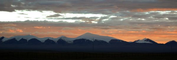
 It is an obligatory section on the route between Qinghai and Tibet and represents a sudden rise in altitude from 2,800 metres to 4,700 metres (9,200-15,400 ft.). The temperature and air pressure drop rapidly as you ascend, so this hike isn’t for the faint of heart. It has also enjoyed great fame for the stunning Kunlun Jade, which is predominantly mined here.