Weizhou Island

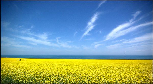
The magnificent Penglai Island is a legendary place in the East China Sea, where fairies dance about the forests and immortal Tai Chi masters roam the mountains. It is an island where, if you’re lucky, you too can achieve immortality. Throughout history many powerful leaders, including Qin Shi Huang, wasted countless resources and spent their lives searching for this mythical place. If only they’d gone to the South China Sea first, then they’d have found Weizhou Island, a real paradise on earth! Weizhou was formed over 10,000 years ago by volcanic eruptions, making it the youngest and largest volcanic island in China. It is just 67 kilometres (about 36 nautical miles) from Beihai City Port and, like Beihai, benefits from luxuriously hot subtropical weather.

The island is only 6.5 kilometres from north to south, and 6 kilometres from east to west, but its unspoiled natural landscapes and thriving wildlife make it an idyllic place to relax and get away from the hustle and bustle of the city. The splendid coral reefs in the waters, rigid pines of the forest and plump cacti blanketing the cliffs make for a sumptuous visual feast. It’s no wonder that people thought the island was a mythical place! Over thousands of years, the numerous volcanic eruptions that have taken place on the island have helped produce unusual landforms, such as the cliffs near Nanwan Port. However, don’t be plagued by nightmarish visions of lava! There hasn’t been an eruption on Weizhou for over 7,000 years.

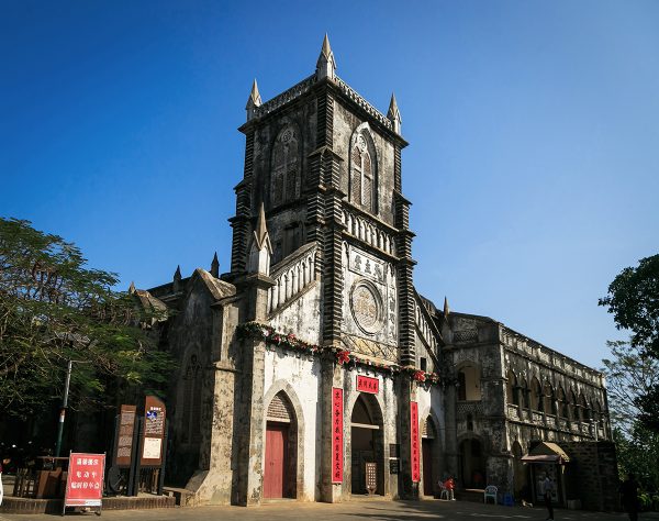
Considering Weizhou was formed by fire and brimstone, it seems rather odd that it is home to two of the first Catholic churches ever built in China. From 1869 to 1879, French missionaries set about building a Gothic-style Catholic church in the small fishing village of Shengtang, which is now referred to as the Weizhou Catholic Cathedral. Once it was completed, they built the Saint Maria Church in Chengzai village, meaning that you never have to go too far for Sunday Mass on this small island! These churches were built using a special type of coral rock, giving them an extraordinarily unique appearance. They are now open to visitors, although the Catholic Cathedral in Shengtang is considered the most popular. The sight of this western-style cathedral, located alongside the eastern-style Sanpo Temple, aptly portrays how international these fishing villages have become, thanks in part to tourism and in part to the historical Maritime Silk Road.

If you’re feeling a little less holy and a little more hellfire, you can always take a trip to the Volcanic Park just west of Nanwan Port. The park boasts a variety of unusual volcanic formations, including Crocodile Hill, Pirate’s Cave, and Moon Bay. There’s also a lovely little Geological Museum where visitors can learn more about how the island was formed and what types of fossils they may find scattered throughout the park.

Since it is an island, Weizhou is not without its fair share of beaches. West Beach, with its soft sand, sparkling waters, and fresh seafood barbecues, is widely considered to be the finest on the island. It’s the ideal place to enjoy a refreshingly cold beverage, frolic in the sand, indulge in some snorkelling, or go diving with an instructor and marvel at the sparkling coral reefs. You can even book a space on a glass-bottomed boat and admire the marine life from the safety of your seat. However, it is important to note that there are no lifeguards on the beach so you must be very careful when swimming or taking part in other water-sports. Along with West Beach, the Multi-coloured Beach on the east coast is not without its charm. When the sun rises on this volcanic stone beach, the sunlight reflecting off of the wet, crimson rocks looks truly spectacular.

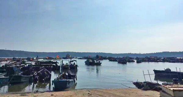
Fishing is the main source of income for many of the locals, but there are also plentiful banana plantations littered throughout Weizhou. We recommend hiking or renting a bicycle from one of the hostels so you can explore the island and take some photographs. Just be sure not to slip on those banana peels! Once you’ve worked up a healthy appetite, you can retire to one of the villages and sample some of the freshest seafood dishes in Guangxi. There are many small eateries and restaurants scattered throughout the island and, since seafood is abundant in Weizhou, most dishes are incredibly cheap. They only vary in price depending on the rareness of the seafood, what the catch of the day is, and what the weather conditions have been like, so having dinner may start to feel like seafood roulette!

Weizhou can be easily reached from Beihai port via ferry, which departs daily at 8.30am, 11.15am, 4.00pm and 5.30pm, and takes approximately 3 hours. There are reasonably regular return ferries to Beihai or, alternatively, you could stay in one of hostels on the island. These hostels are of good quality and private, air-conditioned rooms are usually available on request.

Xieyang Island

Xieyang Island is 9 nautical miles to the southwest of Weizhou and is only a twelfth of the size. There is one small path, which leads from the north side of the island to the south, and only about 100 people call this small, isolated place home. The island has become famous for its myriad of exotic birds and its tranquil forests. Visitors to Weizhou can rent a boat to Xieyang and admire the simple, unchanged lifestyle of its locals.

Beihai Silver Beach

Who can resist a day out at the beach? The sun on your back, the soothing sound of the waves, the glittering soft sand beneath your feet, it’s the ideal way to spend a hot summer’s day. Yet, for most of us, a trip to the beach means a long drive spent anxiously waiting for the cool sea breeze and the first sweet taste of ice cream. In Beihai, Silver Beach is only 10 kilometres away from the city centre! Silver Beach is celebrated as the greatest beach in China and boasts rare grey-white quartz sand, which gives it its distinctive silvery appearance. Sparkling in the sunlight, both the silvery sands and crystal clear waters look far too tempting to pass up. After one day at Silver Beach, you may just scrap your retirement plans in Hawaii and decide to move to Beihai instead!

This wonderful white beach stretches 24 kilometres along the southernmost coast of China and varies from 30 metres to about 300 metres in width. Its popularity is in part due to its renowned safety, as the waves are particularly gentle and there are no sharks or other harmful wildlife in the water. This makes it an ideal place for parents to bring their children, as the beach is a safe haven for adults and youngsters alike. The beach is split into three sections: Beihai Silver Beach Park, Beihai Beach Park and Qiaogang Beach. The two beach parks have an admittance fee but the beach itself is free. These parks boast unusual buildings, a children’s swimming pool, a marine biology museum, an open-air dance floor, and even an exotic bird exhibit. If the beach just isn’t exciting enough for you or you’ve been out in the sun so long that you’re starting to look a bit like a lobster, you might want to take a stroll around the beach parks and enjoy the various attractions on offer.

In the middle of the beach, there’s a bridge that appears to go nowhere. This bridge is known as Fairy Bridge or Immortal Bridge. According to legend, a Japanese monk had come to China on a pilgrimage and happened to be walking along Silver Beach when all of a sudden he saw a rainbow drop out of the sky. The shimmering rainbow landed in the middle of the beach and, from a distance, the monk could see two figures stood on the rainbow discussing something. The monk rushed towards the rainbow but, before he could reach the talking figures, the rainbow vanished, leaving behind only this bridge. The monk supposedly spent the rest of his days praying at this bridge, hoping to catch another glimpse of the mysterious figures. That being said, we don’t recommend spending your day out praying at the bridge.

On top of sun-bathing and swimming, Silver Beach hosts a myriad of activities that are sure to tempt you. You can indulge in a little volleyball on the sand, go snorkelling in the clear blue waters, catch the adorable sand crabs as they skitter out of their holes, or go-cart along the seafront. If you fancy passing a more leisurely day, the beach is lined with several kiosks, shops, and restaurants. Here you can purchase small souvenirs, sample some of the freshest seafood delicacies, or simply enjoy an ice cream as you watch the other visitors frolic on the sand. Just be sure not to drop your ice cream, or the sand crabs might just pinch it!

The Three Parallel Rivers

Taking up only 0.4% of the country’s area yet somehow managing to support 20% of its plant species and 25% of its animal species, the protected areas around the Three Parallel Rivers are some of the most bio-diverse in the world. Altogether 15 protected areas along the three rivers were made into a World Heritage Site by UNESCO in 2003 because of their biodiversity and phenomenal landforms. The site represents the point where the Yangtze (Jinsha), Mekong (Lancang) and Salween (Nujiang) rivers run parallel for over 300 kilometres. This is rather miraculous in of itself, considering these are the 3rd, 12th and 25th longest rivers in the world respectively and, while the Yangtze eventually flows into the East China Sea at Shanghai, miles away the Mekong empties into the South China Sea at the city of Ho Chi Minh in Vietnam and still further the Salween flows into the Indian Ocean at Moulmein in Burma.

Some of the gorges in these areas boast a depth of over 3,000 metres (9,800 ft.), making them twice as deep as the Grand Canyon! At the bottom of the gorges the climate is sub-tropical, whilst along the top there are mountain ranges sporting over 100 snow-covered mountains that are higher than 5,000 metres (over 16, 400 ft.). With all these different temperature zones, you can see how this area has come to support so many plant and animal species. The protected areas are inhabited by a phenomenal 6,000 species of plants, 173 species of mammals, and 417 species of birds, including red pandas, snow leopards, Lady Amherst’s pheasants, Asiatic wild dogs, and the incredibly rare Gaoligong Pika. The animal species found here are a wonderful mixture of the wildly beautiful and the painfully cute!

Of the many snow-capped mountains littered through the Three Parallel Rivers National Park, the Meili Snow Mountain is considered the most famous. Its tallest peak, Kawagarbo, looms over the surrounding countryside at an elevation of over 6,500 metres (22,100 ft.) and the whole range itself is considered sacred by the local Tibetan monks. As of 2001, it is illegal to climb the mountain as its status as a religious site means it would be sacrilegious to set foot on it. So be sure not to climb it or you’ll be arrest for high treason! If you travel to the town of Shenping in Yunnan, you’ll be rewarded with a stunning view of the mountain range and may even see a few of the Tibetan pilgrims completing their circuit of it on foot.

The Meili Snow Mounta in is part of the eight geographical clusters that make up the national park and each one offers something new to its visitors. The Gaoligong Mountain Area is the most extensive and, as such, features cavernous gorges, dizzying cliffs, bubbling streams, thundering waterfalls, primeval evergreen forests, and settlements of the 25 ethnic minorities that call the area home.

The Yunling Mountain Area is home to the most diverse community of animal species, including the elusive Yunnan golden monkeys that can be found nowhere else on earth. And the Haba Snow Mountain Area boasts a modern oceanic glacier, an Indian azalea forest, alpine lakes, snow-capped mountains, and lava formations. Each of these clusters feels like an ethereal paradise and, with all of these choices on offer, you may never find your way out of the mountains!

From the luxuriant forests to the reddish sandstone Danxia landforms and the verdant alpine meadows, the protected areas of the Three Parallel Rivers represent a visual feast that should not be missed. You can access parts of the national park from the cities of Dali, Lijiang or Shangri-la in Yunnan. Most of the treks can take upwards of a week or more, so say goodbye to your creature comforts and prepare to get a little wild!

Mount Heng

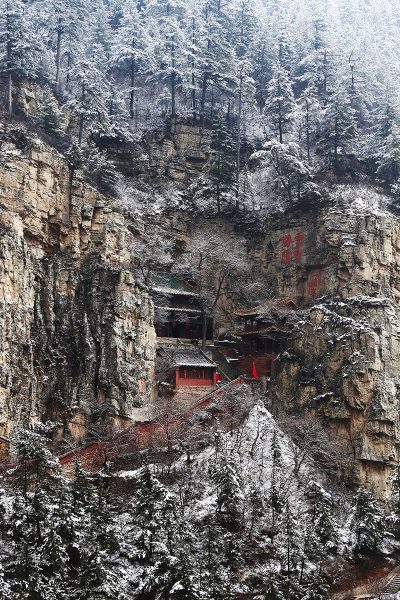
Located just 62 kilometres (39 mi) south of Datong City, Mount Heng is a behemoth of a mountain range and consists of over 100 separate peaks. Not only is it considered one of China’s Five Great Mountains, but it also boasts the highest peak of them all, Tianfeng Peak, which towers in at over 2,100 metres (6,900 ft.) in altitude. To put that into perspective, it’s nearly twice the size of Ben Nevis, the tallest mountain in the UK! Yet it’s not the mountain’s size that has earned it such prestige, but its religious value. According to the Chinese religion of Taoism, Mount Heng is considered a sacred mountain and has been a site of pilgrimage since the Zhou Dynasty (c. 1045-256 BC).

It is sometimes referred to as Northern Hengshan because there is another Mount Heng in Hunan province which is coincidentally also one of the Five Great Mountains. Although their names are written differently in Chinese, they are pronounced in the same way and so the prefixes “northern” and “southern” are used to differentiate them. Imagine having twins named “Stephen” and “Steven”, and you get the idea!

According to legend, over 4,000 years ago Emperor Shun (c. 2294-2184 BC) was on a tour of his northern territory when he came upon Mount Hengshan and was so impressed by it that he simply named it Beiyue (北岳) or “Northern Mountain”. When it came to imperial prestige, Mount Hengshan had literally reached the pinnacle! Another legend purports that Zhang Guolao, one of the Eight Immortals in Taoist mythology, secluded himself on the mountain and is still there somewhere practising his faith. So if you bump into any strange old men while you’re hiking, be sure to be polite!

The mountain was held in such high esteem that a temple known as the Shrine of the Northern Peak or Beiyue Temple was erected there during the Han Dynasty (206 BC– 220 AD) and was dedicated to the god within the mountain. During the Qin Dynasty (221-206 BC), Emperor Qin Shi Huang not only named it as one of the 12 most sacred mountains, but also regarded it as the “Second Greatest Mountain in the entire World”. From then onwards, emperors, scholars, travellers, poets, monks, and people from all walks of life came to visit this alluring mountain range. Many of them left behind stone inscriptions extolling its incredible beauty, which can still be seen along the mountain paths today.

However, its northerly location meant that it was frequently cut off from China proper, as historically northern China was often under the control of non-Chinese kingdoms. This meant that it was not as accessible to pilgrims as the other Five Great Mountains, and so as a consequence it is the least-developed and least-visited of the five. Although therefore it is considered to have less religious importance, it is also less crowded and less commercialised, making it a more peaceful and isolated place to go hiking. In the summer, its hills come to life in a flurry of lilac blossoms, and its verdant pines, elms, firs, poplars, and bountiful forests provide stunning views throughout the year.

Alongside the Beiyue Temple, perhaps its greatest claim to fame is the Hanging Temple, which has survived for more than 1,500 years clutching precariously to the side of a cliff. The temple’s unusual appearance, coupled with the fact that it is dedicated to not just one religion but to Buddhism, Taoism, and Confucianism, means it has recently become a mecca for visitors looking to explore China’s architectural curiosities.

Yet this isn’t the only bizarre feature the mountain has to offer. The Kutian or “Sweet and Bitter” Wells are located about halfway up its slope and are simply two wells placed very close together. For reasons unknown, the water from one well is sweet and refreshing, while the water from its neighbour is bitter and has a distinctly unpleasant aftertaste. Perhaps one well is the other’s evil twin! In spite of the fact that the “sweet” well is only a few feet deep, its waters are inexhaustible, further adding to the mystery of this exceptional oddity. In fact, during the Tang Dynasty (618-907), Emperor Xuanzong visited the “sweet” well and found it so fascinating that he christened it “Dragon Spring”.

The area surrounding Mount Heng is distinctly less magical, as it was once a battleground and its plains have been ravaged by centuries of warfare. Relics of these ancient skirmishes can be found littered throughout the landscape, from tactical passes and small fortresses to colossal castles and beacon towers. The most well-known of these is Golden Dragon Gorge, which is a deep yet narrow pass that was used by General Yang Ye of the Northern Song Dynasty (960-1127) to resist an invasion from the neighbouring Liao Dynasty (916-1125).

Other natural sites on the range include Sisters-in-Law Cave, Flying Stone Cave, Tiger Wind Gap, and Clouds Out Cave, which are all symbolically named and as such are imbued with a certain mystical quality. Clouds Out Cave is arguably the most spectacular as, on a clear and sunny day, it looks like any other cave, but when it’s raining or foggy then mist will billow out of the cave’s entrance and endow it with an ethereal appearance. Perhaps it’s haunted by the soldiers who died in Golden Dragon Gorge; perhaps it’s where Zhang Guolao lives; or perhaps there’s just a hole somewhere in the top of the cave!

The Mount Heng is one of the many wonderful stops on our Explore the Ancient Tradition of Tai Chi tour

The Kanas Lake Nature Reserve

kanas lake

The remote Kanas Lake Nature Reserve rests in the northernmost reaches of Xinjiang and is over 180 kilometres (112 mi) away from the nearest town, making it an area resplendent with virtually untouched natural beauty. It is situated close to the borders between Kazakhstan, Mongolia, and Russia, and it contains the aptly named Youyi or “Friendship” Peak, which is the landmark where China, Russia, and Mongolia approximately meet. The word “Kanas” means “beautiful, rich, and mysterious” in the Mongolian language and, with its towering snowy peaks, thick green forests, and turquoise hued waters, it certainly lives up to the title!

Its primary attraction is the expansive Kanas Lake, which rests deep within a valley of the Altay Mountains. Its crystal clear waters originate from the Kanas Glacier and run for over 125 kilometres (77 mi) along the Kanas River before finally joining the lake itself. It was formed over 200,000 years ago as a result of glacier movement and is the deepest freshwater lake in China, plunging in at depths of up to 120 metres (394 ft.). Stretching out over an area of 45 square kilometres (17 sq. mi), it is over three times the size of Lake Windermere!

kanas villageSeasonal changes and weather conditions endow the lake with a constantly changing appearance. In May, melted snow from the surrounding peaks turns the water a greyish blue colour; in July, it turns a bright aquamarine; in August, the algae turns the water a deep green; and from September onwards it goes a rich turquoise. As if in tandem with these watery wardrobe changes, the surrounding alpine forests also evolve, with dense greens in spring, thick multi-coloured blankets of flowers in summer, and lush golds, reds, and yellows in autumn.

Yet don’t let Kanas’ idyllic appearance fool you; it’s not like your typical lakeside retreat. Temperatures here can plummet to -24°C (-11°F) in winter and rest at an average of about -4°C (39°F), reaching heights of just 18°C (66°F) in July. So if you’re taking a trip to this natural paradise, be sure to wrap up warm! The low temperatures mean it is the only region in China that is home to Siberian animal species and, with over 117 different species of bird regularly nesting here, it’s also a haven for bird-watchers.

But these aren’t the only strange creatures prowling the area, or at least that’s what paranormal researchers would have you believe. Since the 1980s, rumours of the Kanas Lake Monster have enthralled visitors and nowadays sightings of it occur once or twice every year. It is even said that, on the odd occasion, it drags local livestock into the lake’s murky depths! Scientists believe the most likely culprit to be a large taimen or Siberian salmon, which people have mistaken for an otherworldly creature. These freaky fish can reach lengths of nearly 2 metres, so it’s no wonder people might be horrified at the sight of them! Another bizarre phenomenon is that the sixth bay, which rests at the end of the lake, is flanked by a 2,000-metre-long (6,500 ft.) bank of dead trees. No one knows exactly what is stopping the trees from floating downriver, but locals will tell you it’s because they’re reluctant to leave the beautiful lake!

Kanas mountainsThese days the lake is a popular destination for hiking, rafting, rock climbing, paragliding, and boating, with the most popular hike being the one to Guangyu Pavilion. This scenic spot offers a stunning panoramic view of the surrounding mountains and grasslands. In terms of accommodation, Burqin is the closest town and the best option if you want easy access to the lake. From there you can also visit the nearby village of Hemu, which is a popular site for tourists as its home to people from the Tuvan ethnic group, a Siberian people who have Mongolian, Turkic, and Samoyedic roots. The village rests on the Hemu Grasslands and visitors have the choice of either staying with a Tuvan family or venturing onto the plains and staying in a yurt with people of the Kazakh ethnic minority. It’s a wonderful way to connect with other cultures, sample their delicious local dishes, witness their centuries-old customs, and experience their unique way of life. That being said, bear in mind that the Tuvan people trace their ancestry back to the legendary troops of Genghis Khan, so be sure not to get on their bad side!


Zhangye Danxia Landform

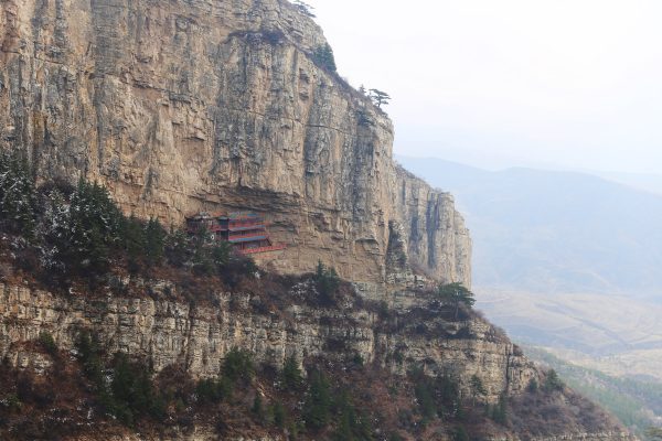
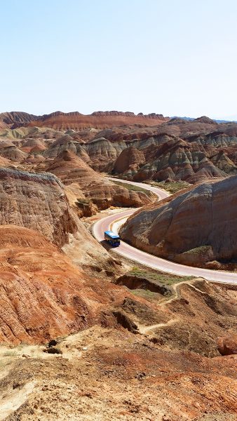
Danxia Landforms, named after Mount Danxia in Guangdong province, are stunning geological formations that are unique to China. They were formed when red sandstone and other minerals were deposited by rivers over a period of about 24 million years. These deposits settled into distinct layers and, after another 15 million years, faults in the earth created by tectonic plate movement caused them to become exposed. Over another few millions of years, they were moulded into strange shapes by weathering and erosion, resulting in the unusual landforms that we find today. Yet the ones near Zhangye are arguably the most spectacular as, rather than just being made up of fiery red sandstone, the hills are a flurry of vibrant colours that resemble a living watercolour painting. For this reason, they have earned the nickname the “Rainbow Mountains”.

Nowadays the Zhangye Danxia Landform Geological Park is the best place to get to grips with this alien terrain. It’s located at the northern foothills of the Qilian Mountains, which only serve to amplify the scenic quality of this magnificent place. The Linze Scenic Area just 30 kilometres (19 mi) west of Zhangye forms the core of the park and is the most popular area, exhibiting the famous “layer cake” hills whose perfect stripes of colour resemble a well-made trifle. Just don’t go trying to take a bite out of them! The Binggou Scenic Area is not quite as popular or as well developed for tourism, but rests on the northern bank of Liyuan River and offers unique, isolated views for those more adventurous hikers. From the shimmering lakes and bubbling brooks to the extraordinary shapes and colours of the rippling hills, the Zhangye Danxia Landform is a work of art that you can literally walk on.

Watch the video about Danxia Landform:


Make your dream trip to the colourful Danxia come true on our travel: Explore the Silk Road in China and Explore “The Good Earth” in Northwest China

Qinghai Lake

The name “Qinghai” literally means “Cyan Sea” and, as the largest lake in China and one of the largest saltwater lakes in the world, it commands so much prestige that the entire province of Qinghai is named after it! This colossal water-body has an average depth of between 19 to 21 metres (62-69 ft.) and covers a surface area of over 4,300 square kilometres (1,660 sq. mi). That’s over five times the size of New York City! According to local Tibetan Buddhists, who regularly circumambulate this watery behemoth as part of their pilgrimage, it can take upwards of 15 to 23 days to complete a full circuit of it on foot.

The lake is located about 100 kilometres (62 mi) west of Xining, the provincial capital of Qinghai, and has unsurprisingly become a popular tourist attraction in the region. Since it rests at an altitude of about 3,600 metres (11,800 ft.), it benefits from temperate, dry summers and is thus the perfect retreat for those wishing to escape the oppressive humidity in other parts of China. In spite of its salinity, the lake also supports several species of fish so you know that, if you enter any of the small restaurants on the lake’s shore, fresh fish is bound to be on the menu!

Yet the lake’s greatest attractions are the many islands dotted across its surface, the most famous of which is Bird Island. Every year throughout April and May, many species of birds use the lake as a resting stop whilst they migrate across Asia. In some cases, the birds settle here and even lay their eggs, which led to the establishment of the Qinghai Lake Natural Protection Zone in 1997. The vast majority of these birds gather on a couple of little islands in the northwest of the lake known collectively as Bird Island. During peak season, over ten thousand birds can be seen perched on these small rocks, laying their eggs or chirruping their sweet songs. Whether you’re a bird-watcher or not, the spectacle of seeing so many birds in one place is not to be missed!

Towards the west of the lake, an island known as Mount Haixin or “Heart of the Lake” is host to several stunning temples and was supposedly once home to a Buddhist monastery. According to legend, the monks who lived there did not own a boat and had no other means of traversing the water. They would wait till winter each year, when the lake would freeze over for three months, and then would cross the icy expanse on foot. It is also rumoured that Emperor Yang of the Sui Dynasty (581-618) commissioned his officials to raise horses on this isolated island.

Nowadays the lake is the site for the annual Qinghai Lake International Cycling Race. Fortunately it takes place in July, around about the same time as the Tour de France, so that’s already a lot of the competition out of the way! Approximately 250 cyclists from about 15 countries gather for this prestigious race, which covers a gruelling 1,300 kilometres (808 mi) at an altitude of 3,300 metres (10,800 ft.). Considering the distance from Beijing to Shanghai is only about 1,200 kilometres (746 mi), we won’t blame you if you decide to remain a spectator!

The Bashang Grasslands

The thundering hooves of a thousand horses led by Genghis Khan as he raided northern China; the soulful songs of opera performers as they entertained Qing Dynasty emperors; the quiet trudge of the Chinese army as they marched off to another battle; these are but a handful of the many scenes that the Bashang Grasslands have played witness to over hundreds of years. Nowadays the gentle rolling hills and wide open plains serve as a place for cattle and sheep to graze, punctuated only by the Mongolian yurts that stand out like small pearls on the jade-green grass. Resting just 280 kilometres (174 mi) north of Beijing, it comes as no surprise that these magnificent grasslands have become a popular tourist location for the capital’s locals.

They cover a large portion of northwest Hebei province and rest at the junction where the North China Plain and the Inner Grasslands of Mongolia meet, making them part of the Inner Mongolia Plateau. Located at the foot of the Yan Mountains, the area is home not only to grassland but to wetlands, dense forests, shimmering lakes, and powerful rivers. With over 300 plant species growing throughout its meadows, the Bashang Grasslands have become known as a rich treasure trove for many of the ingredients used in Chinese medicine. So if you’re hiking through the plains and happen to develop a nasty headache, there’s no need to reach for that ibuprofen. You’re already surrounded by natural painkillers, panaceas, and even a few aphrodisiacs!

Overall the grasslands cover an area of 350 square kilometres (135 sq. mi) and can be split into four parts: Fengning Bashang, Zhangbei Bashang, Weichang Bashang and Guyuan Bashang. These parts rest in four separate counties of Hebei respectively, with Fengning Bashang being the closest to the city of Beijing.

Since the average altitude of the grasslands is around 1,500 metres (4,900 ft.) above sea level, it’s technically higher than many of the mountains in the Beijing area. This means that the temperature is, on average, about 10°C cooler on the grasslands and this is perhaps why the area has been a popular summer resort since the Qing Dynasty (1644-1912). When you’re sweltering in the 30°C heat of Beijing’s summer and are trapped in an underground train full of sweaty passengers, a rural paradise made up of expansive grassy plains and cool fresh air must sound too good to be true!

Yet by far the greatest draw to the area is the nomadic Mongolian culture. Imagine horse-riding or cycling through the grasslands all day, watching a local wrestling competition, sampling the tantalising fresh roast lamb after watching it cook on an open fire, and then settling down to a night of sweet sleep in an authentic Mongolian yurt. With only the sound of the lowing cattle lulling you to sleep and with the bright stars of the clear night sky twinkling above you, you’ll wonder why anyone would want to live any other way.

The Dunhuang Yardang Landform

yardang

While he was travelling through the treacherous Lop Nur region of Western China, Swedish explorer Sven Hedin (1865-1952) came upon a group of strange rock formations just outside of Dunhuang. He named them “yardangs”, a term that is still in use today. Yet you’d be right to think that the word “yardang” doesn’t sound particularly Swedish! It was derived from the Chinese name “Yǎ Dān Dìmào” (雅丹地貌), which literally means “small solid hills with a sharp cliff”.

Yardangs are the result of severe weathering, where wind and rain have stripped all of the soft material from the rocks and left only the hard material behind. Over a period of approximately 700,000 years, this erosion produced the wonderfully bizarre rock formations that we find today. They have characteristically wide bottoms that gradually taper off towards the top, giving them an appearance similar to the hull of a boat, although there are huge variations in their size and shape.

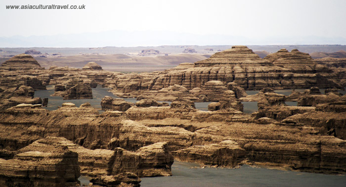
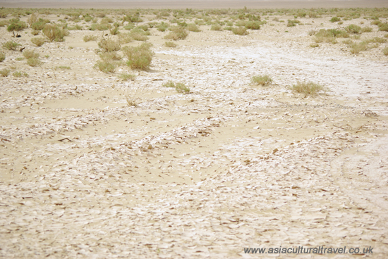
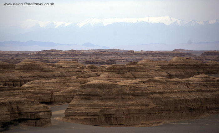
China owns the largest distribution of yardangs in the world and, of these, Dunhuang Yardang National Geopark contains the lion’s share. Exhibiting over 300 square kilometres (116 sq. mi) of yardangs, it covers an area over 100 times the size of the city of London! It’s rumoured that, if you use your imagination, some of these them begin to look like famous world sites, such as the Leaning Tower of Pisa and the Pyramids of Egypt. That being said, to you they may all just look like rocks!

From the Han Dynasty (206 BC–220 AD) onwards, one of the ancient Silk Road’s southern branches passed through this eerie alien landscape. Trading caravans would frequently get lost for several days amongst the yardangs, as they were notoriously difficult to navigate, and the monstrous shapes of the rocks, coupled with the ghostly sound of the wind whipping through the narrow passes, resulted in the area being nicknamed the “Town of Demons”. From the “Camel” and the “Stone Bird” to the “Peacock” and the “Golden Lion Welcoming His Guests”, this geopark is haunted by a myriad of stone animals.

Located just 185 kilometres (115 mi) from Dunhuang and about 85 kilometres (53 mi) west of the legendary Yumen Pass, the Dunhuang Yardang National Geopark is a must-see attraction for those eager to explore the weirder side of the Gobi Desert and the Silk Road. Surrounded by the unnerving silence of the desert and faced with the alien shapes of the yardangs, it’s no wonder people have become fascinated with this spooky place.

Dunhuang Yardang National Geopark is one of the many wonderful stops on our travel: Explore the Silk Road in China

The Gobi Desert

gobi desert

The Gobi Desert is the largest desert region in Asia and the fifth largest desert in the world. This huge expanse spans over parts of northern and northwestern China and heads deep into southern Mongolia. To the north, it is bordered by the Altai Mountains and the Mongolian grasslands, while to the west it is separated from the Takla Makan Desert only by the snow-capped Tian Shan Mountains. The Hexi Corridor and Tibetan Plateau rest at its southwest and the North China Plain is to the southeast. Bordered by rugged cliffs, snowy mountains, and lush grasslands, the rich diversity of scenery that can be found throughout the desert is truly breath-taking.

It covers an estimated area of 1,300,000 square kilometres (500,000 sq. mi), making it larger than the countries of Germany and France combined! Though romanticised depictions of this colossal desert portray it as a massive expanse of golden sand, it’s mainly made up of bare rock. This means that, in a scene worthy of the film Mad Max, visitors can easily traverse large sections of the Gobi from the comfort of their jeep.

It can be separated roughly into several regions: the Gaxun Gobi, Junggar Gobi, and Trans-Altai Gobi in the west; the Eastern or Mongolian Gobi in the centre and east; and the Alxa Plateau or Ala Shan Desert in the south. The landscapes of these areas vary wildly from barren desert steppe to inhabitable semi-desert.

Since it rests at a high altitude far to the north, the temperature fluctuations between seasons and even throughout the day can be incredibly vast. Temperatures can soar to scorching heights of up to 45 °C (113 °F) in July but then plummet to icy depths of −40 °C (−40 °F) in January. The northeast enjoys a decent level of rainfall, which allows sparse vegetation to grow, but some of the more arid areas can go without rain for up to three years! The strong north and northwesterly winds whip up sand and snowstorms throughout autumn, winter, and spring so, in short, don’t buy a holiday home in the Gobi Desert!

SV-AS3  ImageDataIn the more hospitable semi-deserts, several large mammals such as wild camels, dzheiran gazelles, and Przewalski’s horses roam freely. There is even a subspecies of brown bear known as the Gobi bear, which is the only desert dwelling bear in the world, although it is estimated only approximately 50 remain in the wild.

With such an unforgiving climate, it’s unsurprising that the population density of the region is low. The vast majority of people living in and around the Gobi desert are of the Mongol ethnic minority, although there are now also large constituencies of Han people. Nomadic pastoral farming is the main occupation, with herders raising cashmere goats, sheep, large-horned cattle and Bactrian camels, as well as a small handful of horses.

These nomads migrate several times throughout the year and can travel upwards of 190 kilometres (120 mi) between grazing sites. To put that into perspective, if you were travelling about 95 km/h (60 mph) by car it would take you about 2 hours to get from one grazing site to another, so imagine how long it would take driving a herd of animals on foot!

Historically, it was part of the great Mongol Empire throughout the 13th and 14th centuries, and the southern part of the Alxa Plateau formed one of the major routes along the Silk Road. This gave rise to the magnificent Mogao Caves, which stand as a testament to the many travellers that passed through the Gobi in ancient times. This collection of Buddhist temples dating back to the 4th and 5th centuries can be found near Dunhuang City in Gansu province and were designated a UNESCO World Heritage site in 1987.

Gobi desertThe Gobi Gurvansaikhan National Park in southern Mongolia rests in the north of the Gobi and is home to several rare species of animal, including the Gobi camel and the snow leopard. A huge stretch of sand dunes known as the Khongoryn Els extend across 100 kilometres (62 mi) of the park and are up to 300 metres (980 ft.) in height. It’s also home to the famous mountain valley known as Yolyn Am, which is so deep that the ice at its base never thaws, even during the scorching hot summer!

Explore the Gobi Desert on our tour: Explore the Silk Road in China